Sunday, June 19, 2016

Valley Forge NHP - American Revolutionary War Site

Valley Forge National Historic Park is a 3,500 acre park created to tell the story of the Continental Army during the winter of 1777-78.  Valley Forge had a battle but it wasn’t against the British.  It was a battle for survival (about 2,000 soldiers died during that winter from cold and disease).   It was added to the National Register of Historic Places in 1966 and was established as a National Historic Park on July 4, 1976. 

BACKGROUND:  “On December 19, 1777, the Continental Army consisting of 12,000 troops marched into Valley Forge.  For the next six months, the divided groups of militiamen would band together to form a true army, one capable of taking the fight to the British.”  

The 10 mile self-guided driving tour features 9 main stops.  Click on the link at the bottom of this post to print a map of the park/driving tour (Plan Your Visit).  An 8.7-mile paved multi-use trail parallels most of the driving tour route.  
NPS Park Map/Driving Tour
Our visit to Valley Forge NHP begins in mid-afternoon.  The first thing we do is go to the Visitor Center’s theater (in a separate building) and watch the 18-minute movie about Valley Forge. The main building of the Visitor Center includes exhibits and a large gift shop. 

The Visitor Center is Stop 1 on the 10-mile Encampment Tour Route.  It’s about 4:15 p.m. when we begin our driving tour of the park.  The skies are gray and a light rain is falling ... at least it isn't snowing or freezing cold like it was when George Washington was here.

Spend a While in Ohiopyle State Park (PA)


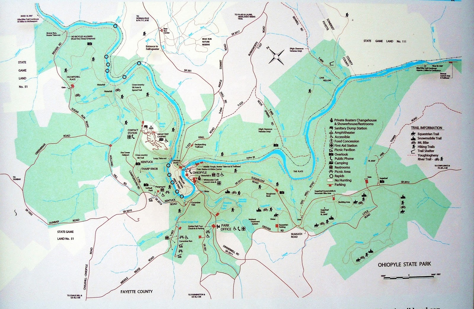
When my Hubby suggested we visit the 20,000-acre Ohiopyle State Park, I wasn't too excited ... at first.   Once we got there I enjoyed hiking some of the 75 miles of trails and seeing the waterfalls.  Of course, there are other things to see and do as well (mountain biking, cross-country skiing, snowmobiling, and horseback riding - not all trails are suitable for each activity).  It also includes over 14 miles of the Youghiogheny (pronounced yawki-gay-nee) River Gorge great for whitewater rafting.  Unfortunately, the whitewater rafting trip will have to wait for another visit.  
Park Map
The name Ohiopyle is believed to come from a Native American Indian word "ohiopehhla" meaning “white frothy water”.
Our spring visit to Ohiopyle State Park begins in mid-afternoon with a stop at the Visitor Center.  There are exhibits on the lower level as well as a glass-enclosed area for viewing the nearby waterfall.
Visitor Center
Lower Level Exhibits
View of Falls from Visitor Center's Lower Level
In addition to seeing Ohiopyle Falls (which is right next to the Visitor Center), the staff recommends going to the scenic Baughman Rock Overlook and Cucumber Falls.  The Park has several waterfalls.  Two of them are easy to see (Ohiopyle Falls and Cucumber Falls).  The other waterfalls require some hiking.  Since our time here is limited, the other waterfalls will have to wait for a future trip.  

From the Visitor Center’s lower level, I see a few kayakers on the river a short distance from the base of the falls.  Under certain conditions, kayakers are allowed to “shoot the falls”.  It’s not on my “to do” list but there are some adventurers who enjoy the ride. 
Kayakers on the Yough River

Wednesday, June 8, 2016

Gettysburg National Military Park (U.S. Civil War Site)

While we are visiting Pennsylvania, we had to stop in Gettysburg and tour the Park.  In 1895, the federally protected Gettysburg Battlefield was designated a National Park.  It was established for the purpose of protecting and interpreting the landscape of the 1863 Battle of Gettysburg.  In 1966, it was listed on the National Register of Historic Places. 
From July 1-3, 1863 over 160,000 men fought at the Battle of Gettysburg.  It was the bloodiest single battle of the American Civil War.  At the end of the three-day battle, about 50,000 men (and one woman) were killed, wounded, or missing.  Wait a minute - a woman was killed during the battle? 

Monocacy National Battlefield (U.S Civil War Site)

My Hubby and I enjoy visiting historical sites.  So, during one of our visits to the eastern United States, we toured several battlefields - including the Monocacy National Battlefield.

Monocacy National Battlefield is a 1,500+ acre park that was established on October 21, 1976.  The Battle of Monocacy was fought on July 9, 1864.  It is also referred to as "The Battle That Saved Washington," and was one of the last battles the Confederates would carry out in Union territory.   It was listed on the National Register of Historic Places and designated a National Historic Landmark on November 8, 1973.
Entrance Sign
NPS Map
I would allow 1-2 hours to see this Park.   Starting at the Visitor Center is a good way to begin a visit to the Battlefield.  The main floor features the flags from the States that fought in this battle as well as a book store.  We go to the second floor where there are exhibits and an electronic map describing the events of the day.  There are restrooms at the Visitor Center too.
Visitor Center
State Flags
2nd Floor - Electronic Map of the Battle
The Park has six hiking trails.  They are located at the Visitor Center as well as the Worthington Farm (stop 3), the Thomas House (stop 4), and Gambrill Mill (stop 5). You might consider allowing a little extra time to hike some of thesw trails.

Now that we know a little about the battle, it's time to begin the auto tour ...

Antietam National Battlefield (U.S. Civil War Site)

The Antietam National Battlefield is a 3,230-acre Park that was established on August 30, 1890 to preserve the battlefield site and honor those who fought here.  This Battlefield was listed on the National Register of Historic Places on October 15, 1966.
On September 17, 1862, the Battle of Antietam (aka Battle of Sharpsburg) was the first battle of the Civil War to be fought on Union ground. The 12 hours of fierce fighting resulted in more than 23,000 casualties (killed, wounded, or missing) making it one of the bloodiest single-day battles in the history of this nation. 

So, why is this battle known by two different names?  

Saturday, May 28, 2016

Climb the Tower - Point Iroquois Light

Aaah, the history and mystery of lighthouses seem to beckon us to stop whenever we are near one.  Point Iroquois Light in Michigan's Upper Peninsula is the one we are revisiting today.  
Point Iroquois Light
Miniature Replica of Point Iroquois Light near Brimley, Michigan
BACKGROUNDPoint Iroquois was named for the Iroquois warriors massacred there by the Ojibwe in 1662.  By 1856, the first Pt Iroquois Light was lit to guide ships safely between Whitefish Bay and the St. Mary's River.  Its wood and rubble-stone tower was 45 feet high.  However, the structure was not constructed well.  In 1870, the first light station was demolished and the current light station was built.  The new 65’ brick tower had a fourth order Fresnel (the “ess” is silent) lens.   In 1963 its light was deactivated and the light station was left unoccupied for years.  It was placed on the National Register of Historic Places on May 30, 1975. 
It took several years to complete the renovation but it was accomplished through the co-operative efforts between the Bay Mills/Brimley Historical Society and the Forest Service (Hiawatha National Forest). In an effort to interpret local history, they furnished the assistant keeper’s quarters to show how it might have looked in the 1950’s.    
Assistant Keeper's Quarters - Living Room
Assistant Keeper's Quarters - Kitchen
Inside the two-story house is a gift shop offering lighthouse-themed items and books.  We wander through several rooms with a variety of informational displays regarding keeper’s duties, Fresnel lenses, and nautical history. 
Gift Shop
Fresnel Lens Display
The attached white brick tower has a spiral stairway consisting of 72 steps to the top of the tower.  Michigan has over 100 lighthouses but only about 20 will allow you to climb the tower.
Tower Rules
Doorway to Tower Stairs
Tower Stairs
Hatch at Top of Tower
From the top of the tower, we have a panoramic view of Lake Superior, the coastline of Whitefish Bay, and any freighters that may be passing by the point.  One thing you should know - the lantern room is small and the glass-enclosed space gets very warm especially on a sunny summer's day.
View from Lantern Room/Top of Tower
Before we leave the lighthouse grounds, we take a short walk (.2 mile) on the interpretive boardwalk trail that leads to the beach along Lake Superior.  Some people are searching for rocks along the shore.   In my youth, I was a “rock hound” too.  Once in awhile I’ll search the shores for these souvenirs but not today … maybe on our next visit. 
Boardwalk Trail
Trail to Lake Superior Beach
LOCATION & CONTACT INFORMATION:  The lighthouse is located about 20 miles west of Sault Ste. Marie in Michigan’s Upper Peninsula  (USA) - from the intersection of M-28 and I-75 drive 7.5 miles west on M-28 to M-221/ Brimley. Turn right (north) and drive 2.5 miles on M-221 to Lake Shore Drive (FR 42). Turn left (west) on Lake Shore Drive and drive 6.5 miles to the lighthouse.   
Telephone:   (906) 437-5272
HOURS OPEN:  The museum, gift shop, and tower are open every day from May 15 - October 15 from 9 a.m. to 5 p.m.  There isn’t a fee to tour the building or climb the tower; however, donations are always appreciated.  There are restrooms and picnic tables on the grounds. 

The town of Brimley (population in 2010 was 1,337) is about 8 miles from the lighthouse.  It is a small town offering a few lodging and dining options. 

Sault Ste. Marie (population 14,098 in 2013) is about 20 miles from the lighthouse.  The “Soo” has a large variety of restaurants and lodging options ranging from large national chain establishments to cozy B&B’s.

Since opinions, preferences, and budgets vary, I recommend checking a trusted travel source for current reviews for eating and sleeping options.

If you are interested in other nearby lighthouses, I invite you to view my blog posts by clicking on the following links:
Crisp Point Light: from Doomed to Resumed
Whitefish Point - Light, Lodging & Lake Superior

If you are staying in Sault Ste. Marie, I invite you to view my blog posts on the Soo Locks and historical landmarks by clicking on the following links:
A Look at the Locks
Historic Sites at the "Soo"

Friday, May 27, 2016

George Washington Slept Here - Fort Necessity National Battlefield

During one of our spring trips, we toured many historic sites and battlefields.  I was familiar with many of the Civil War sites but the American Revolutionary War sites ... not so much.  Quite frankly, I never heard of Fort Necessity.  So this was something new for me.  

This park landpreserves the site of the Battle of Fort Necessity. The battle, which took place on July 3, 1754, was an early battle of the French and Indian War, and resulted in the surrender of British colonial forces under Colonel George Washington, to the French and Indians, under Louis Coulon de Villiers.  The site also includes the Mount Washington Tavern, once one of the inns along the National Road.”*   
In 1769, George Washington bought 235 acres of meadows where he had commanded his first battle 15 years earlier.  He called the land “Mount Washington” and thought it was a perfect place for an Inn.  Unfortunately, he died (December 14, 1799) before the National Road or Tavern was built.

Fort Necessity National Battlefield was established on March 4, 1931. I think it is an appropriate date since March Fourth is considered the only commanding day of the year – “Soldiers, March Forth!”