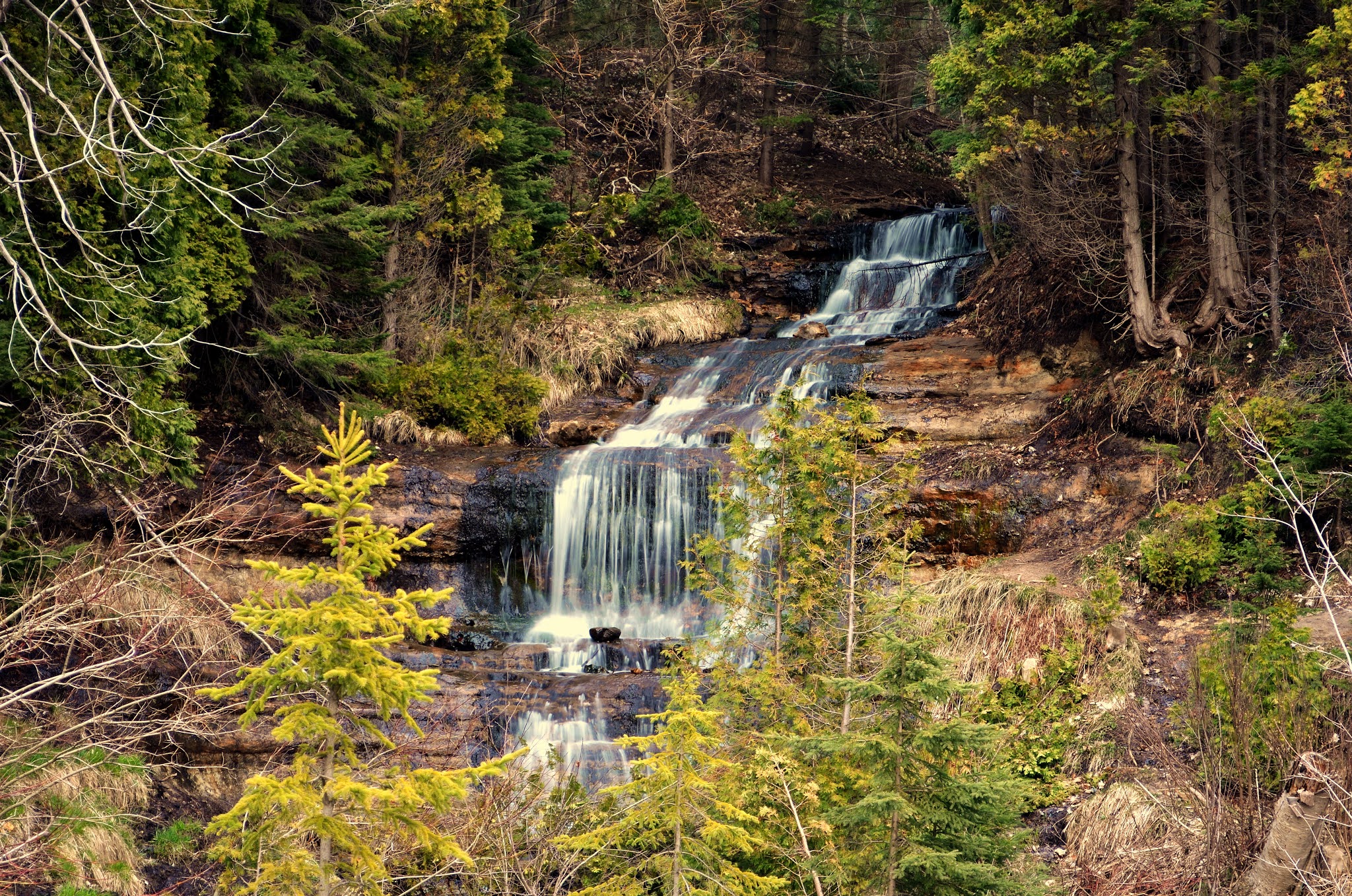
Scott
Falls:
This roadside waterfall drops 10 feet into a small pool of water. During our mid-April visit, snow and ice are clinging to the rocky
walls surrounding the falls. A month later, the ice has melted and
the snow is almost gone.
Scott Falls
Location: On M-28 about 8 miles west of Munising
across from a roadside park
Wagner
Falls:
Wagner Falls (20’ drop) is
located in a small park with a boardwalk trail. We have been
here a number of times in the spring and fall. In April, layers of
snow blanket the wooden boardwalk and forest floor into a frosty but
monochromatic landscape. In autumn, the colorful leaves provide pops
of color.
Wagner Falls
Location: Wagner Falls State Scenic Site,is south of Munising
on M-94 (near the junction of M-94 and M-28)
Whitefish Falls:
While the copper-colored water of Whitefish Falls reminds me of the
root-beer colored water at Tahquamenon Falls, the similarities stop
there. Whitefish Falls is more of a cascade and not very impressive
especially when compared to other waterfalls in Michigan’s Upper
Peninsula. Still, as a waterfall wanderer, I value its simplistic
beauty.
Location:
From
the intersection of M-67 and US-41 near Trenary, head northwest about
3.5 miles to State Forest Campground Road, turn left onto the dirt
road for about 450 feet. Find
a place to park and walk about 150 yards to the bank of the river.
FYI… this
road continues and will loop around to US-41 as River Road.
PICTURED
ROCKS NATIONAL LAKESHORE WATERFALLS: (Alger County)
Pictured
Rocks NLS is famous for its colorful cliffs, recreational activities,
and scenic beauty. Listed among these “must see” things to do
are the iconic waterfalls located within its boundaries. Some are
easily accessible and some require a bit more effort.
Location:
Pictured Rocks National Lakeshore extends 42 miles along the
southern shore of Lake Superior between the towns of Munising and
Grand Marais, Michigan (USA).
Elliot
Falls (aka Miners Beach Falls):
In
my opinion, Elliot Falls is one of the Park’s best kept secrets.
It is easily accessed and located at the end of a sandy beach with
a 180 degree view of Lake Superior. During our July 4th
visit, we watched tour boats, kayakers, and pontoon boats paddle or
casually motor by Miners Beach. Who knows … maybe the people on
the boats were looking at us and wishing they were sitting on the
beach too.
Elliot Falls
Location:
From H-58, follow Miners Beach Road until you reach a T
intersection, head to the right and the parking for the Lakeshore
Trail This small dirt parking area provides access to area trails and Miners Beach. A
short trail leads to Lake Superior and Elliot Falls.
Memorial
Falls:
The
trail to 40’ high Memorial Falls passes through a forest. A boardwalk foot bridge along the
forest trail crosses the river near the top of the falls. A
short distance later, the trail goes down a steep hillside and
continues hugging the sandstone wall until we reach the falls. I am
disappointed. The last time we were here (1990’s), we were able to
walk behind the waterfall. Now, "trail ends" and "no
climbing" signs warn visitors not to go beyond the wooden fence
at the small observation deck. We take our pictures and leave.
Memorial Falls
Location:
From Munising, head east on Munising Avenue, turn right
on Nestor Street and follow the signs. Street parking is allowed in designated areas.
Miners
Falls:
This picturesque waterfall is a very popular attraction. During peak
season, parking may be difficult. However, this is not a concern for
us during our mid-April trip. We hike the 1.2 mile (round trip)
trail. Today, we are the first visitors to walk through the
unspoiled snowy forest trail to the falls. Every turn in the trail
offers another view of this winter wonderland. There are two
observation decks – one at the end of the trail and the other
descends 64 steps for a better view of the 40’ high Miners
Falls. The blanket of white snow and icicles clinging to the
rocky sides create a magical appearance rewarding those who make the
effort to see it during the colder weather.
Miners Falls
Location:
From Munising, take H-58 to Miners Castle Road., then
follow the signs.
Munising
Falls:
Because of its accessibility, Munising Falls is a popular destination
when visiting the town of Munising. The falls can be found at the
end of a ¼ mile paved trail. A canopy of leaves keeps the area
shaded and cool on a warm summer day. My first visit here was in
1987. At that time, visitors were able to walk around the sandy
trail that passed behind the 50’ high falls. Now, the wooden
boardwalk trail ends at a wooden viewing deck. A series of wooden
stairs allow visitors the option of walking the trails that
ascend the sides of the sandstone walls above the river. Munising
Falls is beautiful in its own way during each of the four seasons.
Munising Falls
Location:
From Munising, travel east on H-58 to Washington Street. The parking
lot for Munising Falls is across from the hospital.
Potato
Patch Falls:
The hike to Potato Patch Falls is
roughly 1/10 of a mile. While the distance is short the terrain is a
bit steep. At the same parking lot we used for Miners Beach and
Elliot Falls, we begin our hike to Potato Patch Falls. The trail is the same trail used to hike to Mosquito Beach and Falls.
During
our July visit, the trail had a well-worn, trough-like appearance
looking more like a dry intermittent creek bed …. but it's not. I am glad I
have my walking sticks. We hike to the top of the ridge and follow the narrow trail on the left.
We can only see the top of the falls from here. We head back down
the trail toward the parking lot and find a side trail (now on our
right) that will lead us to the falls. The side trail drops down and
then follows a sandstone wall. The falls are in a "u"-
shaped canyon much like Munising Falls, Tannery Falls, and Memorial
Falls. While the waterfall has more of a “wispy” or “wimpy”
appearance, we are happy to see water flowing over the lip of the
sandstone ridge down to the pool below it.
Potato Patch Falls
Location: From Miners Beach, follow the trail to
Mosquito Beach/Falls.
Sable
Falls:
From the parking lot, Sable Falls is a short walk (about 500 feet)
down a dirt trail through the forest. Then you see them … not the
falls but the first of many stairs down to the river. We go down the
stairs to the first mini wooden deck. The trees are blocking most of
the view of the falls. So, we continue going down the wooden stairs.
Down...down...down... by my count there were 202 stairs to the main
viewing deck near the river.
From here, Sable Falls tumbles 75 feet over ledges and rocks as the
river swiftly makes its way to Lake Superior.
Sable Falls
Location: On H-58 about one mile west of Grand Marais
on the east end of Pictured Rocks NLS
Tannery
Falls (aka Rudy M. Olson Memorial Falls):
On
H-58, near the Washington Street junction, look for a wooden staircase
on the south side of the road. This marks the beginning of a narrow
cliff trail to Tannery Falls. Since parking is not allowed on H-58,
an acceptable parking space must be found on Washington Street.
Another way to access a longer trail to Tannery Falls is at the same
location for the Memorial Falls trail from Nestor Street.
We
park our car on Washington Street. During our 10 minute walk to the
falls, we pass by sandstone cliffs. The primitive dirt trail is
narrow in spots. There aren’t any fences, so we take our time and
enjoy the stroll. We cross a short wooden foot bridge and go up the hill
for a better view of the falls. Centered in a sandstone alcove is
the 40’ high Tannery Falls.
Tannery Falls
Location:
On H-58 about 1.5 miles west of Munising
BARAGA
COUNTY WATERFALLS:
In
October of 2017, we decided to go to Mount Arvon (Michigan’s
highest point). Along the way, we stop to photograph Black Slate
Falls, Quartzite Falls, and Ravine River Falls. Both Black Slate
Falls and Quartzite Falls are accessed from the same parking area.
Location:
Black Slate Falls and Quartzite Falls are about 12.5 miles east of
L’Anse via Skanee Road to Arvon Road. About three miles from
Skanee Road is a bridge that crosses the Slate River.
Black Slate Falls
We
park the car off the side of the road. The trail to
Black Slate Falls is upstream from the bridge (part of it can be seen
from the bridge). These falls drop about four feet over the edge of
a rock formation. The Slate River continues to cascade its way
downstream to Quartzite Falls.
Black Slate Falls
Quartzite Falls:
The
short trail to Quartzite Falls is downstream from the bridge. The
Slate River glides over rock shelves dropping about eight feet over
slate edges into pools on its journey downstream.
Quartzite Falls
Location:
About 12.5 miles east of L’Anse via Skanee Road
Ravine River Falls
This
lovely and delicate waterfall can be easily seen from the car.
Ravine River Falls
Location:
A roadside waterfall located on Ravine
River Road on the way to Mount Arvon
Canyon
Falls:
This area is nicknamed “The Grand
Canyon of the Upper Peninsula”. The
parking lot has picnic tables and restrooms. The
trail to the waterfall is an easy mile walk along a combination of
boardwalk (through swampy areas) and a well defined dirt trail
passing through a predominately pine forest. Soon, the trail
parallels the Sturgeon River and we begin to see a series of
cascading water sliding over black rock. A short distance later, is
the viewing platform for Canyon Falls (15’ drop). The falls are
located at the bend in the river. Beyond
the falls the river has cut a gorge into the rocks, and a more rustic
trail continues along the rim of the gorge.
Canyon Falls
Location: This 10-acre roadside park is located 14
miles south of Baraga on US-41.
Power House Falls:
The Falls River has a number of waterfalls through the L’Anse area.
Power House Falls are next to the old power house in a small park.
At this spot, the Falls River drops 15 feet as it tushes its way
toward Lake Superior. Unfortunately, during our visit, there is a
decomposing deer carcass near the falls and the smell is quite
unbearable.
Power House Falls
Location: From US-41, drive 1.5 miles south of L’Anse
and turn right on Power Dam Road and follow the signs.
Tioga Falls:
A short walk along a dirt trail leads to the falls. While it isn’t the most
impressive waterfall, it is a good opportunity to get out of the car
and stretch your legs. Insects can be bothersome during warm
weather.
Tioga Falls
Location: 20 miles south of L’Anse on US-41 at a
roadside park.
CHIPPEWA
COUNTY WATERFALLS:
Tahquamenon
Falls (Upper and Lower):
At
almost 50,000 acres, Tahquamenon Falls State Park is Michigan’s
second largest state park.
Location:
Upper Falls are located about 14.2 miles from the town of Paradise via M-123
Upper Falls:
At nearly 50’ high and 200’ wide, the Upper Falls are the largest
falls in Michigan. The falls are beautiful any time of the year.
The half mile paved trail leads to a several overlooks offering
slightly different views of the Upper Falls and river. At the “T”
intersection of the paved trail, we turn right and continue walking
along the forest path to the top of the metal stairway.
We leave the shady comfort of the tree-lined river bank and descend
94 steps to a wooden observation deck at the brink of this “mini”
Niagara Falls. I enjoy watching the mist from the Upper Falls
rising and creating rainbows. From this spot, we can see upstream
(to our right) where the water tumbles over rocks before dropping over
the lip of the falls in a white water frenzy, and
continuing downstream (to our left).
Upper Tahquamenon Falls
After we spend a little time here, we return to the fork in the trail
and continue walking along the left side to a set of stairs (116
steps) that will lead us to a river level view of the Upper Falls.
Lower
Tahquamenon Falls:
It’s a short drive from the Upper Falls to the parking lot and
trailhead for the Lower Falls. The Lower Falls consists of several
small drops along a short stretch of the river. It’s a pleasant
walk through the forest on an easy boardwalk trail to a couple of
large wooden decks overlooking the river.
Lower Tahquamenon Falls
Location:
The Lower Falls is 11.4 miles from Paradise via M-123
GOGEBIC
COUNTY WATERFALLS:
Gabbro Falls:
The viewing spots here are limited and small in size. Also, there
aren’t any fences or guardrails so be very careful when visiting
these waterfalls. That being said, Gabbro Falls and Gorge is one of
my favorite waterfall sites. The white water plunges down the black
rock walls, tumbles its way through the gorge, and offers me a
landscape of unexpected beauty.
Location:
From
US-2 in Wakefield, go west about 2 miles to Blackjack Road to
Blackjack Mountain Big Snow Resort. Just before you cross the
bridge, you will see a sign indicating it is the trailhead for the
falls. We didn’t go that way. Instead, we continued over the
bridge on Blackjack Road and
makes a sharp turn to the lef. (resort
is on our right). Just
up the hill, the road makes a sharp curve to the right. We parked
along this stretch of road. The falls are a quick walk through the
woods on unmarked narrow trails.
Yondota
Falls:
The
narrow dirt trail to Yondota Falls parallels the Presque Isle River.
It does not take long to arrive at the section of the river where the
"falls" (more like cascades) are located. The trail was
short and fairly easy to walk.
Yondota Falls
Location:
Take County Road 523 for about three miles north of the
town of Marenisco.
The trailhead is just north of the bridge,
BLACK
RIVER RECREATION AREA:
Today,
we are heading to the Black River Recreation Area for a little hiking
and waterfall viewing. There are five main waterfalls (Rainbow,
Sandstone, Great Conglomerate, Gorge, and Potawatomi) in this area.
Be prepared to get some exercise because there are a lot of steps
here.
Location:
The Black River Recreation Area is about 15 miles north of Bessemer
and about 30 minutes from Ironwood.
Great Conglomerate Falls:
The
trail is a short 3/4’s of a mile (1.5 miles round trip) to Great
Conglomerate Falls (30’ drop). The trail descends steadily
(including 100+ steps) to the Black River where there is a small
viewing platform. At the falls, the river separates into two sections
around an island of conglomerate rock (thus its name). This is a
classic example of a “segmented” waterfall.
Great Conglomerate Falls
Rainbow Falls
The
first trail to Rainbow Falls (west side of river) isn't that long
but it involves 190 steps to get down to the viewing area. Here, the
river plunges 45 feet over conglomerate rock. It isn’t the best
view. There is another observation deck on the opposite (east) side
of the river. We will try that trail.
The
trail to Rainbow Falls that goes to the east side of the river is
located at the Black River Harbor area. The 3/4 mile trail involves
about 170 steps to the overlook. This side of the
river does offer a better view of the falls. We
can see the viewing platform where we were earlier.
Rainbow Falls
Sandstone Falls
Sandstone Falls is
considered the least impressive of the main waterfalls. The trail to
Sandstone Falls is only 1/4 mile in length but has 140 steps to
negotiate down to the river (and then back up). The birch tree
trunks have green moss clinging to the white bark. The spring greens
from the leafing trees is a welcome sight after a long drab winter.
We reach the falls. Despite its smaller size, I like it. The river
forces its way between two rock walls dropping about 20 feet. It continues to curve and carve its way around more rock walls on its
way to Rainbow Falls before emptying into Lake Superior.
Sandstone Falls
Gorge Falls
We
drive to the parking lot where we can see both Gorge Falls and
Potawatomi Falls. We walk the trail (designated a National
Recreation Trail) to the Black River. To
reach the viewing platforms overlooking the river and waterfalls, we
need to climb 200+
steps. But
it’s totally worth the effort.
From
the first platform, we can see Gorge Falls and the river swiftly
moving downstream. At the top of the falls, the river narrows to
about seven feet. The water drops about 20 feet into a gorge (thus
the name Gorge Falls). The water may have a reddish brown color
(some call it a copper color). This color is caused by the tannic
acids from the hemlock trees. This is the same thing that gives the
Tahquamenon Falls its "root beer" color.
Gorge Falls
Potawatomi Falls
A
short trail through the forest brings us to the river where we can
view Potawatomi Falls. The trail to the falls is 550 feet from the
parking lot through a forest to the river. While there are wooden
steps to the falls, it is not as many as there were on the other
trails. The falls split in two as it drops about 40 feet around a
massive conglomerate stone.
Potawatomi Falls
PORCUPINE MOUNTAINS WILDERNESS STATE PARK WATERFALLS (Gogebic
County:
At almost 60,000 acres, this is Michigan’s largest State Park. It
is located in two Michigan counties (Gogebic and Ontonagon). Within
its boundaries are miles of rivers and streams which help to create
wild and wonderful waterfalls. While
there are a number of waterfalls in this section of the Park, most
people only see two - Manabehzo Falls and Manido Falls. They are the
last two waterfalls along the Presque Isle River before it makes its
way to Lake Superior. The trailhead parking lot has restrooms. I
recommend using these facilities before starting your hike.
Location: Porcupine Mountains Wilderness State Park is 13.5 miles west of Ontonagon via M-64N or 30 miles from Ironwood
These waterfalls are off South Boundary Road on the west side of park
along the Presque Isle River
Manabehzo
Falls:
We walk a short distance down the
dirt trail before the series of wooden steps and boardwalk begin.
We access the boardwalk (and more steps – I lost count) that
stretches about one-half mile along the Presque Isle River.
At Manabezho Falls the river drops
about 20 feet over a rock ledge that spans the 150’ wide river.
There is an observation deck.
Manabezho Falls
We continue walking the trail to
Manido Falls.
Manido
Falls :
A small wooden observation deck offers a view of Manido Falls. I
like these falls too. While Manabezho Falls is a stunning single
drop, Manido Falls tumbles about 20 feet over rocks creating a fine example of a cascade-type
waterfall.
Manido Falls
Nadawaha Falls:
From the trailhead on South Boundary Road, we hike 3/10’s of a mile
through a forest that parallels the Presque Isle River. From our
slightly elevated view, we watch the Presque Isle River drop about 15
feet creating Nawadaha Falls. In the Ojibwa language, “Nawadaha”
means “in the midst of the rapids”.
Location:
These falls can be viewed from both sides of the river. The west
side has a short
(100 yards) well
marked trail beginning at the camper registration station on Presque
Isle Road. To view from the east side of the river, from the
intersection of Presque Isle Road and Forest Trail 117/South Boundary
Road, we turned east and crossed the bridge. There is a parking area
across the road from the trailhead. Use caution when crossing the
road.
HOUGHTON
COUNTY WATERFALLS:
Hungarian
Waterfall Area:
Someone suggested we should see the waterfalls in the Hungarian
Waterfall area. We drive south on US-41 and turn on M-26 in
Lake Linden and continue to the little town of Hubbell. We are told there are at least three waterfalls in a short distance of each other in this area.
We gather our cameras and tripods and begin hiking the trail.
Within 4/10's of a mile we see three falls. The first falls are
mostly obscured by the trees along the trail. We continue to the
middle falls. We are up on a ridge looking down at it. While I stay
on the ridge, my Hubby scrambles down the side of the trail to the
river's edge. From there, he gets a better view of them.
Hungarian Area Waterfalls
A stone's throw from the middle falls is the third falls. It is a
smaller waterfall but worth seeing. .
KEWEENAW COUNTY WATERFALLS:
Eagle
River Falls:
The remains of a dam still span the 60 foot wide river and help to
create an even more dramatic falls (total height of well over 60
feet).
Eagle River Falls
Location: Eagle River Falls are located in the
Village of Eagle River on M-26.. The falls are to the right of the
historic bridge that spans the Eagle River.
Jacob’s
Falls:
A few miles after Eagle River (heading north on M-26) is another
roadside waterfall called Jacobs
Falls. White streams of water cascade 40 feet down the rough
rock to create this charming falls.
Jacob's Falls
Location: On M-26 three miles northeast of the town of
Eagle River
Silver
River Falls
Silver
River Falls is another roadside falls. To really see them, we take a
short walk downstream.
Silver River Falls
Location:
About 4 miles east of Eagle Harbor on M-26 (near the access to
Brockway Mountain Drive)
Haven
Falls
Haven
Falls is a fan-type waterfall that drops 20 feet down a steep rocky
slope. The falls are visible from the road.
Haven Falls
Location:
At a roadside park in the town of Lac la Belle on the eastern side of
the Keweenaw Peninsula
Manganese
Falls
The
river plummets down a narrow gorge creating Manganese Falls (45’
drop). I recall the forest trail being a
fairly
easy walk
to the falls.
Manganese Falls
ONTONAGON COUNTY WATERFALLS:
Agate Falls:
We first visited Agate Falls in 1995. At that time, we could hike
the steep-bank trail down to the river and view the entire 39’ high
Agate Falls. During our 2008 visit, we noticed a wooden boardwalk
trail has replaced the dirt trail. The boardwalk ends at a
fenced-off wooden platform meant to discourage visitor’s from
hiking any further. Standing at the wooden platform, we can still
see where the dirt trawl continued to the river bank below us. From
here, we have a restricted view of the top of the falls. For safety
and environmental purposes, the change was probably necessary. In
2020, we accessed the trestle (now used for hikers, bikers, and
ATV’s). From the center of the bridge, we can look down at the top of the
falls and the river below us.
Location:
Located
at a roadside park on M-28 about 7
miles southeast of Bruce Crossing
Bond
Falls:
This scenic site has changed over the years. During my first visit,
I don’t remember seeing the boardwalk trails and viewing platforms
that now direct visitors along a loop trail around the falls. Still,
this is one of my favorite waterfalls. Bond Falls drops about 50
feet creating numerous cascades.
Bond Falls
Location: Bond Falls Scenic Site, 10 miles north of
Watersmeet or 9 miles south of Bruce Crossing or about 3.5 miles from
Paulding via Bond Falls Road
PORCUPINE
MOUNTAINS WILDERNESS STATE PARK WATERFALLS (Ontonagon County)
As
mentioned earlier, this State Park is located in two Michigan
Counties (Gogebic and Ontonagon). These are the waterfalls within
the “Porkies” that are located in Ontonagon County.
Location:
Porcupine Mountains Wilderness State Park is 13.5 miles west of
Ontonagon via M-64N or 30 miles from Ironwood
The trails to these waterfalls are accessed from South Boundary Road
Overlooked Falls:
It’s an easy 4/10's of a mile to
Overlooked Falls. A short spur trail (100 feet long) leads us to a
viewing area. The Little Carp River splits in two creating two small but pretty
waterfalls that should not be overlooked.
Overlooked Falls
Greenstone Falls:.
From
Overlooked Falls, we cross the 80 foot long
wooden bridge over the Little Carp River. The 3/4's of a mile trail to Greenstone Falls continues with several sections of long but narrow boardwalk (two boards wide) through wet areas. This is prime habitat for the yellow-colored Marsh Marigolds that we see. It’s a pleasant and easy walk to the
falls.
Greenstone Falls
Nonesuch Falls:
To reach Nonesuch Falls, follow the trail to Nonesuch Mine (some
unidentified ruins of a small ghost town). The falls are a short
distance beyond the ruins. The dirt trail is a former two-track road
that nature is reclaiming. We encounter a couple of muddy stretches
along the trail but it is an easy walk through a forest. We reach a
fork in the trail and turn left following the trail down a hillside.
Here we find stone foundations covered in green moss.
From the ruins, we can hear the rushing sound of a waterfall. The
trail continues down the hillside and ends at the river where we see
Nonesuch Falls.
Nonesuch Falls
Location: The parking lot and trailhead to Nonesuch
Mine and Nonesuch Falls is located at a sharp 90 degree curve in the
South Boundary Road within the Park
.
I will keep updating this blog post with more photos and trail information whenever we get
a chance to visit more of Michigan’s wild and wonderful waterfalls.
While doing these blog posts, I got to wondering about the different
types of waterfalls. I did some research on the Internet. Using
Wikipedia as my main source, I found the following types:
In the Upper Peninsula, food and lodging options vary depending on where you are. If you are visiting the U.P. in the peak fall color season, I strongly recommend making lodging reservations well in advance. Since opinions, budgets, and preferences vary, I recommend checking a trusted travel source for current reviews on food and lodging.


No comments:
Post a Comment
Thank you for taking the time to comment on my travel blog. I review comments on a regular basis and appreciate any feedback offered.