Wednesday, November 1, 2017

Steppin' It Up at Grand Staircase-Escalante National Monument

A couple of years ago, we spent some time in southern Utah.  Between the National Parks, National Monuments, and scenic byways, we keep returning to this area.  

On this particular trip, we will do something new for us. We will explore Grand Staircase-Escalante National Monument.  Obviously, we didn’t see all 1.9 million acres of it but the landscape we did see was pretty impressive.
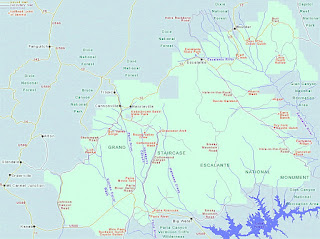
Entrance Sign and Park Map
The main Visitor Center for Grand Staircase-Escalante National Monument is in Kanab (745 E. Highway 89, Kanab, UT, 84741; 435-644-1300). However, you can find other Visitor Centers in Cannonville, Big Water, Escalante, and at Anasazi State Park.    
Visitor Center in Escalante
We were about 10 miles south of Fredonia when we got our first distant view of the “staircase” (at the time we were on our way to the North Rim of the Grand Canyon).   
I wasn’t sure what to expect but I found out this isn’t your typical stairway …

Tuesday, October 31, 2017

Hammin' It Up in the "Porkies"

This year during our fall color tour of Michigan’s Upper Peninsula (U.P for shore), we are spending a couple of days exploring the Porcupine Mountains Wilderness State Park - "Porkies" for short.   
Park Map
The 59,020 acre park was established in 1945 to protect a large stand of old-growth forest. In 1972, Michigan passed the Wilderness and Natural Areas Act. This act gave the “Porkies” a new name - the Porcupine Mountains Wilderness State Park. In 1984, the park was designated a National Natural Landmark due to its natural and historical value. It is one of 12 such designations in the State of Michigan.

If you are like me, you can’t help but wonder how places get their names and the Porcupine Mountains certainly begged to be asked that question. If you didn’t know, here’s the answer …

Thursday, September 21, 2017

M-119 - Scenic Tunnel of Trees Drive

Recently, we stayed at a B&B in Mackinaw City, Michigan (USA). We were having breakfast with a couple from northern Illinois. Later in the week, they were planning to go to Traverse City and driving the Lake Michigan coastline south on their way home. Since they weren't familiar with the Emmet County area, they asked us if there was something they "must see".  So, we gave the obvious answer - "you should drive M-119".  
In 2003, M-119 was officially designated a state Scenic Heritage Road (aka Pure Michigan Byway). According to Wikipedia, this designation is given to "a scenic, recreational, or historic route that is representative of Michigan's natural and cultural heritage".  
I didn't count them but one source reports there are 137 curves along this 20 mile stretch of road from Harbor Springs to Cross Village.  
What makes this scenic drive different?  Well ...

Thursday, July 20, 2017

We're Heading South to the North Rim (Grand Canyon)

During one of our autumn vacations, we visited the American southwest. On a whim, we took a side trip to the North Rim of the Grand Canyon. The first thing we do is stop at the park entrance sign for a photo.   

NPS Park Map
During the 12 mile drive to the North Rim, the sun is shining, bison are grazing along the roadside (I wasn't expecting to see bison here!), and we are listening to jazz tunes by Pat Methany ... we are on our way to a great day here on the North Rim.  

So what makes the North Rim a good place to visit?

Saturday, July 15, 2017

Let's Go To Bob-Lo (Bois Blanc Island)

I  have lived in Michigan all my life and done a fair amount of traveling around this awesome state. But there are still some places I have never visited – like Bois Blanc Island (located in Lake Huron – near Mackinac Island). So, now that the July 4th crowds have gone home, my Hubby says, “Let’s go to Bob-Lo”.


Bob-Lo is another name for Bois (pronounced Bwa) Blanc island. It is French for “white woods”. It is believed that the name was given to the island because of the numerous white-bark trees that exist here.
I was surprised to discover what this quiet and laid-back island has to offer.

Friday, June 23, 2017

Park It at Lighthouse Park (Michigan USA)

Michigan’s State Motto is “If you seek a pleasant peninsula, look about you.” Old Mission Peninsula is a peninsula within Michigan’s lower peninsula. If you are seeking scenic sites, wining and dining, or year ‘round recreational opportunities, this 19 mile long strip of land is the epitome of Michigan’s motto.

There are plenty of things to do in the Old Mission Peninsula but my favorite is visiting Lighthouse Park. It’s a scenic drive to the tip of the peninsula where M-37 (aka Center Road) dead-ends at the park entrance.

Lighthouse Park (120-acres) has trails and a beach area (no lifeguard) and the grounds are open every day until 10:00 p.m.
PHYSICAL LOCATION: 20500 Center Road (aka M-37), Traverse City, Michigan (USA)
Phone: (231) 223-7324

From 1870 to 1933, the Mission Point Lighthouse served as an aid to navigation for those mariners sailing on Lake Michigan.
In 2008, the lighthouse and gift shop was opened to the public. During its normal season (May-October), the lighthouse is open from 10:00 a.m.-5:00 p.m. For a nominal fee, visitors can climb the stairs to the top of the tower. We did this in 2013. A light fog surrounded the area when we arrived at the top of the tower for an 180 degree view of Lake Michigan. At that time, Lake Michigan’s water level was so low that we could walk on the bottom of the sandy lake bed for quite a distance before reaching the water. I am happy to report that during our 2017 visit, it was obvious the Lake Michigan water levels have risen. Inside the lighthouse is an interesting chart showing the fluctuating water levels over the years.
During its active years, the lighthouse had a Fifth Order Fresnel lens. FYI - there are six “orders” of lenses for lighthouses – the first order is the largest and the sixth order is the smallest. “A Fresnel lens can be regarded as an array of prisms arranged in a circular fashion, with steeper prisms on the edges and a nearly flat convex center.” Some lenses can be seen from as far a way as twenty miles or more.

Mission Point Lighthouse is an iconic landmark in the Grand Traverse area. It was designated a Michigan Historic Site on October 15, 1992. It also has the distinction of being located at the 45th Parallel. The 45th parallel north is often called the halfway point between the Equator and the North Pole.   
45th Parallel Signs
Mission Point Lighthouse is surrounded by five acres of wooded land with well marked trails. The Lighthouse Park grounds has handicap parking, picnic tables and two outdoor toilets.

Another building on the park grounds is the Hessler Log Cabin. The cabin was built by Joseph and Mary Hessler. It was completed in 1856 and, today, it represents pioneer life in Michigan. The log cabin was saved from demolition when it was moved to Lighthouse Park.  It was designated a Michigan Historic Site on July 15, 1999.  
  Exterior & Interior

Local History Sign
State Historic Signs
Mission Point Lighthouse is one of many Michigan lighthouses that has a Lighthouse Keeper Program. To learn more about Michigan’s Lighthouse Keeper, Program, please click on the following link:

If you would like to stay overnight at a lighthouse but would prefer to be a guest rather than experiencing some of the duties of a keeper, I invite you to view my Blog Post on Lighthouse B&B’s by click on the following link:   

Immediately south of Lighthouse Park is the Old Mission Point Park (520-acres). There are miles of multi-use trails traversing through forest, meadows, and scenic overlooks. The trails are marked and maps are posted at each trail head. Much of this land was filled with cherry orchards before the State purchased it in the 1980’s. The State later leased the land to Peninsula Township.   
Trail Map Sign

There are lots of things to see and do while visiting the Old Mission Peninsula. I invite you to view my blog post on touring the Old Mission Peninsula by clicking on the following link:

While driving around the Old Mission Peninsula, you will find farm markets and wineries (Chateau Chantel Winery is also a beautiful B&B with scenic views of the East and West Grand Traverse Bays). For more information on Chateau Chantel B&B, I invite you to view my Blog Post on Michigan B&B’s by clicking on the following link:

Old Mission Peninsula does not have any national-chain restaurants or hotels (try Traverse City for these options). However, Old Mission Peninsula does offer several charming Bed & Breakfasts and local restaurants. For a map of the Old Mission Peninsula and other tourist information, please click on the following link:

Since opinions, preferences, and budgets vary I recommend checking a trusted travel source for current reviews. In the meantime, I wish you safe travels!


Friday, June 16, 2017

Sitka Alaska - Totems, Trails, and Trees

At Sitka National Historical Park you will find totem poles standing the test of time, towering trees, and temperate temperatures tempting tourists to traverse the tranquil trails in a rain forest that has a tale to tell. It’s time to take a tour …
Located on the west side of Baranof Island in Southeast Alaska is the town of Sitka. We’ve come here several times on Alaskan cruises. However, cruise ship shore excursions offer only a brief time at various local attractions. For example, on our last trip here, we spent about 20 minutes at the Sitka National Historical Park. We wanted more time to hike the rain forest trails, see all of the totem poles, and learn a little history about the Park. So during our most recent visit (May 2017), we opted to be our own tour guide.

Address: Sitka National Historical Park, 103 Monastery Street, Sitka, AK 99835
Phone: (907) 747-0110
It is an easy walk from downtown Sitka to the Park’s Visitor Center. This is a good place to get information about the Park, see the exhibits, or watch a short video. The restrooms are located at the front of the building.
Visitor Center - Front/Street Side 
Visitor Center - Water View
GENERAL INFORMATION Sitka National Historical Park was established to preserve and interpret the site of the battle of 1804 between the Tlingit and Russians. While Sitka National Historical Park is its official name, the Park is also referred to as Sitka Park, Government Park, Indian River Park, and Sitka National Monument. Another unofficial name is Totem Park.

BACKGROUND INFORMATION: Indian River National Monument was established on March 23, 1910. In 1972, the Park’s name was changed to Sitka National Historical Park and its boundaries were expanded to include the Russian Bishop’s House

HOURS/FEES: The Visitor Center is open year round (except Christmas and Thanksgiving). Hours vary according to the season. The Russian Bishop’s House is open daily (May-October) from 9:00 a.m.-5:00 p.m. This park does not have an entrance fee.

The Russian Bishop’s House (located at 501 Lincoln Street) was completed in 1842 and was part of the Russian Orthodox Church. By 1969, the building was falling into a state of disrepair. The National Park Service obtained the property and began the lengthy process of restoration to its 1853 appearance. It was designated a National Historic Landmark on June 13, 1962. It is one of four surviving examples of Russian Colonial Style architecture in the Western Hemisphere.
Russian Bishop's House
We enjoy history and hiking and this 113-acre Park offers both. It has two loop trails (the Totem Trail and the Russian Memorial Trail).
Park Trail Map
These two trails (total of 1.6 miles) wind through the rain forest and offer coastal views of Sitka Sound and snow-capped mountains – like Mount Edgecumbe (a dormant volcano). I can’t stop taking pictures of it!
Mount Edgecumbe
It is easy to walk the wide and well-maintained trails in this rain forest (no rain today!).  
 Tranquil Trails
Of course, the totem poles are the focus along the Totem Trail. According to the NPS website, “Between 1903 and 1904, Alaska’s Governor Brady toured southern southeast Alaska's Tlingit and Haida villages by ship, asking leaders to donate poles and other objects for an exposition. From the spring of 1904 through 1905, the poles were “on display” in St. Louis and then Portland, Oregon. The poles returned to Sitka in January of 1906, where Brady's concept of a totem pole park would be realized. Before the poles could be installed, they were repaired by skilled local craftsmen.”
 Totem Poles
If you understand what each carving means, you will learn the story each totem pole is telling. Unfortunately, I don’t know what the carvings represent but I do appreciate the beauty of the carvings and their historic value.

While walking the trails, we are pleasantly surprised by the sunny weather and even shed a layer of clothing … mid-May in Alaska – who knew? I love walking through the rain forest. I feel so small in this land of giant trees.
Giant Trees
The forest floor is carpeted in green vegetation. Trees that have fallen become nurse logs providing a foundation for new life to begin.
Nurse Log
We walk along the coastal trail. Adding a little springtime color to the landscape are yellow dandelions growing along the grassy shoreline.
Maybe 20-30 minutes would be sufficient time for some people who visit this Park. However, we spent a leisurely 2.5 hours strolling the trails, watching bald eagles, taking pictures, reading the exhibit signs, and going through the Visitor Center. 

Later, we walked back to downtown Sitka via the Sea Walk (a pedestrian walkway that parallels Lincoln Street) and returned to our ship in time for our “all aboard” at 12:30 p.m.

The Sitka National Historical Park is just one of many things to see and do in Sitka. For more information on Sitka, I invite you to view my blog post by clicking on the following link:
  
For more information on recreational opportunities/tours, lodging, and other attractions in Sitka, please click on the following link:

If you are planning a longer visit to Sitka, I recommend checking a trusted travel source for current reviews on dining and lodging options.  


Wednesday, May 31, 2017

Sitka, Alaska


Sitka is an island in southeast Alaska that is only accessible by boat or plane.  The Russians settled Old Sitka in 1799 giving Sitka its nickname “Alaska’s Little Russia”.

This morning, we are participating in the “Explore Sitka Highlights & Totem Park” tour.   We board bus #8 and begin our tour of the Sitka highlights (crossing the O'Connell Bridge to Japonski Island).  We see the harbor, 3 huge colorful buoys, a bald eagle, and the University of Alaska before re-crossing the bridge back to Baranof Island where Sitka is located. 

Our tour continues downtown where we pass by the Hanion- Osbakken House and St. Peter's By-The-Sea Episcopal Church.
    
Hanion-Osbakken House       St. Peter’s By-The-Sea

We stop at a beach to see a bald eagle but we get an extra treat and see a whale too. 

Next we arrive at the Naa Kahidi Community House to watch the Alaskan Tlingit Natives perform traditional songs and dances from their culture.  The last dance is an invitational dance and members of the audience are invited to participate - so I do.  You simply spread your arms out like the wings of a raven and dance with a limp. 

At the Sitka National Historical Park is a loop trail where totem poles are on display.  Unfortunately, we only have time to walk about 1/3 of the trail.   We do see 6 or 7 of the totem poles before our time here is up and we need to return to the bus. 
                    
For more information on this Park, I invite you to view my Blog Post on Sitka National Historical Park by clicking on the following link:
Denice's Blog Post - Sitka National Historical Park

The bus driver drops us off downtown by St. Michael's Cathedral (a Russian Orthodox Church).   St. Michael’s Cathedral was built between the years of 1844-1848 and was destroyed by fire in 1966 and rebuilt.  The church’s green domes and crosses are a prominent and iconic landmark in Sitka. 
    

In the afternoon, we embark on the “Sea Otter & Wildlife Quest” (Allen Marine Tours).   We are very fortunate today because the waters around Sitka are pretty smooth.  This allows the boat to sail quickly and easily around the area in search of wildlife.  Within 45 seconds of leaving the dock, we see sea otters.  We continue sailing around locating bald eagles and lots of sea otters near Black Rock.  Bieli Rocks (a small rocky island) has three crosses at the top of it honoring those who lost their lives at sea.  We sail by the dormant cinder cone of Mount Edgecombe (3,201').  It was named by Captain James Cook in 1778.  
                   
Cruising for Wildlife Sightings       Bieli Rocks (Island)        
                       
                                                          Mount Edgecombe

We cruise to the 65-acre St. Lazaria Island (National Wildlife Refuge).  Here we see Puffins floating in the water and a rugged coastline.
                    
St. Lazaria Island                             Puffins

Shortly after leaving the Refuge, we spot a couple of gray whales.  We watch them for a short time before moving to another location in search of humpback whales.  We do see whales spouting and making brief appearances but mostly they are playing hide-and-go seek with us.


For more information about Sitka, visit the following website:

For more information on St. Lazaria Island National Wildlife Refuge, visit the following website:
For more information on St. Michael’s Cathedral, visit the following website:
For more information on the Sitka National Historical Park, visit the following website:
For more information on the Naa Kahidi Community House, visit the following websites:
For more information on Allen Marine Tours, visit the following website: