Saturday, July 21, 2018

Hiking Yellowstone: Fairy Falls & Imperial Geyser

One of the best ways to experience Yellowstone is to get out of the car and hike a trail.  Yellowstone has over 900 miles of trails that vary in length and ability levels including about 15 miles of boardwalk trails.

During one of our Yellowstone visits, we hiked the trail to Fairy Falls (2.5 miles one way). Beyond the falls, the trail continues to Imperial Geyser (another 7/10’s of a mile one way) for a total distance of 6.4 miles (round trip).

There are three locations to access a trail to Fairy Falls:
1. One mile south of the Firehole River bridge on the Fountain Flat Drive (hike is 3 miles, one way);
2. South on the Fountain Flat Drive to the barricade signaling the end of road for vehicular traffic (hike is 2.5 miles, one way); and
3. Trailhead parking lot – one mile south of the Midway Geyser Basin parking area (hike is 2.5 miles, one way).

This September morning, the air is cool but the afternoon temperature is expected to be unseasonably warm. Knowing this, we want to be off the trail by noon (it didn’t happen). We drive to the trailhead near the Midway Geyser Basin because it is closest to where we are staying (Old Faithful). 

NPS Map
At the beginning of the trail is an unnamed thermal feature near the Firehole River.
Unnamed Thermal Feature
For the first mile, the trail follows a wide dirt road. We were told to watch for a steep spur trail (about 9/10’s of a mile from the trailhead) that would lead to an overlook at the edge of the hillside with an outstanding view of Grand Prismatic Spring.  *In 2010, this was an unofficial trail. We hiked up the hillside following the trail left by others who came before us. We find the viewpoint and sit on a rock watching the cool morning breezes moving the clouds of steam across the Spring. *Since this was such a popular thing to do, the National Park Service has established an official trail to the overlook with an observation deck. 
View of Trail
We hang around here for about 75 minutes. During that time, we get momentary windows of opportunity to photograph the colorful spring from this elevated vantage point.  
Grand Prismatic Spring
By now, we realize that we will be on the trail longer than we expected.   We need to keep moving.  Fairy Falls is another 1.7 miles down the trail and Imperial Geyser is beyond the falls.

Back on the main trail, we see Grand Prismatic Spring but its shape and size is not as obvious at ground level.   
Grand Prismatic Spring
We continue hiking the trail to Fairy Falls passing through a new growth pine forest. My hubby did some backpacking here in the early 1980’s. He wanted to show me his backcountry campsite but things have changed over the years and he doesn’t recognize where it was.

We continue hiking until we reach Fairy Falls. Here is where Fairy Creek drops 200 feet creating a delicate waterfall cascading down the rock wall into a small pool. The area is littered with fallen tree trunks – nature’s furniture. We pick one to sit down on and listen to the relaxing sounds of the waterfall. We spend the next hour photographing the falls and enjoying the coolness of this rocky alcove. This is a great spot to be on a warm afternoon.
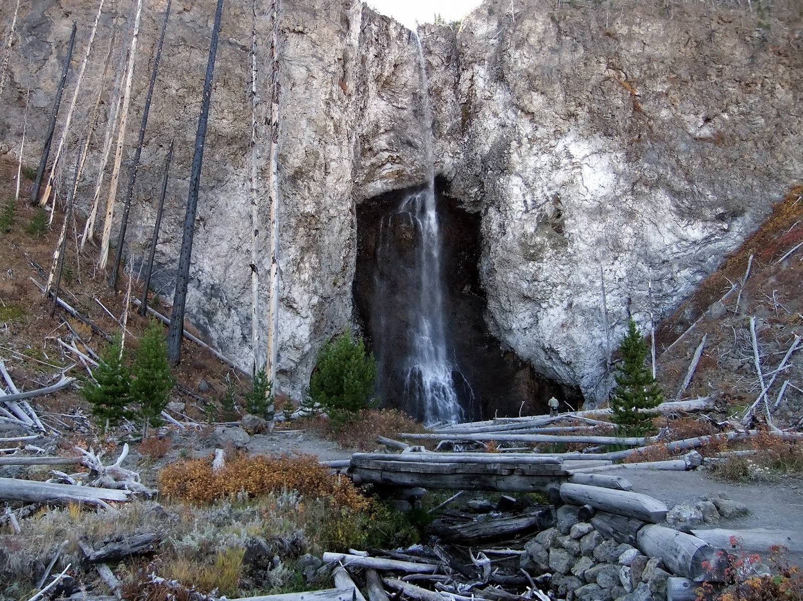
Fairy Falls
Fairy Falls - Close Up
Fallen Logs over Fairy Creek
From here, the trail continues to Imperial Geyser. After crossing a short wooden footbridge built over Fairy Creek, we leave the cool shade behind us and hike the sunlit trail.
Footbridge over Fairy Creek
Along the trail to Imperial Geyser, we pass Spray Geyser.  It's a small but steady geyser just off the trail a bit. While we are here, a passing hiker informs us that we are only two or three minutes from Imperial Geyser.  
Spray Geyser along the trail to Imperial Geyser
A few minutes later, we see Imperial Geyser. It erupts 6-80 feet (we see mostly 6-15 feet bursts) spewing water into the 75’ x 100’ alkaline pool of clear blue water. Orange and yellow-colored run-off edges the pool and creates a narrow thermal creek.
Imperial Geyser
Imperial Geyser
Thermal Run-Off
The return hike to the trailhead is warmer under the afternoon sun.. Once back at the car, we return to Old Faithful for a late lunch/early dinner at the Snack Bar (burger/fries combo) followed by a double scoop of Bunny Tracks Ice Cream at the Old Faithful Inn. I can’t please everybody … Seymour Moose didn’t want Bunny Tracks – he wanted Moose Trax.  Since he wouldn’t eat it – I did and it was yummy!
Seymour Moose with Bunny Tracks Ice Cream
No matter how many times I visit Yellowstone, I never get tired of seeing its ever-changing scenery. I invite you to view my other blog posts on Yellowstone National Park by clicking on the following links:

Planning a visit to Yellowstone? Food and lodging options are available inside the park and in the towns just outside the park (West Yellowstone, Gardiner, and Cooke City/Silver Gate – all in Montana). I highly recommend making lodging reservations in advance. Yellowstone is a popular destination and “No Vacancy” signs are common especially during the peak summer months. Since opinions, preferences, and budgets vary, I suggest checking a trusted travel source for current reviews.

My best advice is this - don’t just drive through Yellowstone – experience it!

The National Park Service has created a series of short videos titled “Inside Yellowstone”. It’s a fast and fun way to learn about the Park. Click on the following link to begin this Yellowstone experience.   

Family vacations created some of my favorite memories. To start planning your memorable trip to Yellowstone, please click on the following link:

Thursday, July 12, 2018

Yellowstone: A Ton of Fun at the Canyon

There are places in the United States that everyone should see at least once in their lives. Yellowstone National Park is one of those places. There’s a lot to see – wildlife, waterfalls, Old Faithful, and, of course, the Grand Canyon of the Yellowstone River.
NPS Map
Grand Canyon of the Yellowstone River
The Yellowstone River is the major force in the creation of this V-shaped canyon. Along with wind and earthquakes (1,000-3,000 small quakes per year), the Yellowstone River continues to carve the canyon. Statistically speaking, the canyon is about 24 miles in length and varies from 800 to 1,200 feet in depth and from 1,500 to 4,000 feet in width.

The Canyon Village, Lodge, and Visitor Center are located 1/8 mile southeast of Canyon Junction. The Visitor Center is always a good place to get current information on trail, road, and weather conditions. We spend a little time viewing a film, browsing through the book/gift shop, and visiting the exhibits which includes a large map that explains the various aspects of the Park’s geology through the use of lights and narration. 
Visitor Center
Exhibit Map with red lights 
showing location & size of Yellowstone Caldera
After the Visitor Center, our first stop is at the Brink of the Upper Falls. From the parking area, the paved trail to the Brink of the Upper Falls is about a tenth of a mile with a slight elevation change of 75 feet. The Upper Falls drop 109 feet. Just because they are not as high as the Lower Falls doesn’t mean they aren’t worth seeing. We’ll see a front view of the Upper Falls later from the South Rim Drive.
Trail to Brink of the Upper Falls
Yellowstone River
Upper Falls
Upper Falls with Rainbow
The rest of the view points are accessible from either the North Rim Drive or the South Rim Drive. We’ll start by taking the North Rim Drive. It is a one-way paved road offering several stops – Brink of the Lower Falls, Lookout Point, Grand View Point, and Inspiration Point. Each of these points has its own unique view of the Canyon.

From the parking lot, the roughly paved trail to the Brink of the Lower Falls is about 4/10’s of a mile. A series of switchbacks leads us 300 feet down the side of the canyon wall to an observation platform offering an excellent view of the top of the Lower Falls.    
Trail to Brink of the Lower Falls
Brink of the Lower Falls
It’s time to climb back up the steep switchbacks to the top. Please use extreme caution when hiking this (or any) trail in the Park.

Since the 1880’s, Lookout Point has been a popular viewing point. Lookout Point is easily accessed from the parking lot by a short trail with a few stairs resulting in a 25-foot elevation change. At 308 feet high, the Lower Falls are the highest waterfall in the Park. At the end of this blog post you will find a link to my post featuring Yellowstone’s Waterfalls that includes these two and other waterfalls we have seen within the Park.
Trail to Lookout Point
Lookout Point - View of Lower Falls
The Grand View Point offers a picture-perfect view of the colorful canyon walls and the Yellowstone River. Now, I am not a geologist; but, I have to ask myself, "what caused the colors in the canyon?" 

According to Wikipedia, “The colors in the canyon are also a result of hydrothermal alteration. The rhyolite in the canyon contains a variety of different iron compounds. When the old geyser basin was active, the "cooking" of the rock caused chemical alterations in these iron compounds. Exposure to the elements caused the rocks to change colors. The rocks are oxidizing; in effect, the canyon is rusting. The colors indicate the presence or absence of water in the individual iron compounds. Most of the yellows in the canyon are the result of iron present in the rock
Grand View Point
Our last stop on the North Rim Drive is Inspiration Point (east end of the canyon). Originally it was called “Promontory Point” because the point stuck out and offered a panoramic view of the canyon. In 1884, the name was changed to Inspiration Point because of the inspiring view and the display of colors found here. In 1975, an earthquake caused a large piece of the point (and observation deck) to fall down into the Yellowstone River. As a result, the view has been slightly altered from its first description in 1878 as “Promontory Point”. However, Inspiration Point is still aptly named.

It’s a short walk to Inspiration Point with only 50 feet of elevation change. We have two options to reach the viewing platforms.  The first option is a handicap accessible walkway leading to the first viewing platform.  The second choice is to take the 70 stairs to the Lower Viewing Platform.  For a little exercise, we take the stairs to the second platform.  From this overlook, the Lower Falls are barely visible but the panoramic view of the colorful canyon is beyond words. I call it an “aah” or “awe” spot.
 Inspiration Point Sign
First Viewing Platform
Inspiration Point
Canyon Walls at Inspiration Point
After we leave Inspiration Point, we stop at the Glacial Boulder (left side of the road) for a quick photo.  This giant boulder measures 24 x 20 x 18 feet and weighs more than 500 tons.
Glacial Boulder
Next, we begin the South Rim Drive which includes stops at Uncle Tom’s Trail and Artist Point.  Uncle Tom’s Trail parking area has a trail that will take us to see the full view of the Upper Falls. The other trail here includes a long stretch of stairs offering an outstanding view of the Lower Falls.

First, we walked the trail to Uncle Tom’s Point for a view of the Upper Falls and the 120-foot long Chittenden Memorial Bridge. Originally built in 1903, it was replaced in 1963 with the current bridge.   
Upper Falls & Chittenden Bridge
Uncle Tom's Trail is short (less than 3/4’s of a mile round trip) but steep trail (500 feet) down the canyon wall for a “feel the power” view of the Lower Falls. This trail does involve climbing more than 300 stairs down to the observation platform.  Before hiking this trail (or any trail in the Park) factors to consider include the time of day, temperature, and your personal capabilities.  We take our time going up and down this stairway system.  The view at the bottom is rewarding and it is worth the effort.

From 1898 to 1903, adventure awaited those early visitors who followed Uncle Tom to the base of the Lower Falls. He ferried them across the river (before the Chittenden Bridge was built) and then led them down into the Canyon using the rough trail he built (and rope ladders) to the base of the Lower Falls.   
The Story of Uncle Tom
Today, a paved trail takes us to the metal stairway where we go down, down, down ....
Uncle Tom's Trail
Stairs and Canyon Wall
At the bottom of the stairs is a viewing platform.  During our visit, we were the only ones here.  This allowed us to really enjoy the quiet wild and natural beauty of the falls and the view downstream. Anytime you are near a waterfall, watch for rainbows!  
 Uncle Tom's Trail - View of the Lower Falls
Uncle Tom's Trail - Yellowstone River
Uncle Tom's Trail - Rainbow
Oh, boy … time to tackle those 308 steps … There are places to rest along the way. We take our time climbing the stairs at a slow but steady pace.

Our last stop along the South Rim is at Artist Point. This area has been known by this name since 1883. It was erroneously thought that this was the viewpoint Thomas Moran used for his painting “The Grand Canyon of the Yellowstone” which was one of numerous exhibits used to help convince Congress to create our first National Park.  FYI … Thomas Moran’s famous painting was from the Lookout Point location.

The trail at Artist Point is 2/10’s of a mile (round trip) with 50 feet of elevation change.   
View from Artist Point
Canyon Wall at Artist Point
If you are seeking some solitude from the hustle and bustle of the popular overlooks, the South Rim Trail to Sublime Point is a good place to go. The three-mile trail (round trip) begins at Artist’s Point and has about 300 feet in elevation change.  The trail follows the edge of the canyon and there aren’t any guardrails. Please be careful when hiking this (or any) trail. There are nice views along the entire trail. At the end of the trail is a small fenced area with the view of Sublime Point. You won’t find a view of the Lower Falls but the colorful canyon walls streaked with evergreen forests creates an outstanding view.
Sublime Point View
We retrace our steps back to Artist’s Point and drive to Canyon Village. There are more hikes and views in the Canyon area.  Unfortunately, we didn’t have enough time to see them. It gives us another reason to return here.

No matter how many times I visit Yellowstone, I never get tired of seeing its ever-changing scenery. I invite you to view my other blog posts on Yellowstone National Park by clicking on the following links:

Planning a visit to Yellowstone? Food and lodging options are available inside the park and in the towns just outside the park (West Yellowstone, Gardiner, and Cooke City/Silver Gate - all in Montana). I highly recommend making lodging reservations in advance. Yellowstone is a popular destination and “No Vacancy” signs are common especially during the peak summer months. Since opinions, preferences, and budgets vary, I suggest checking a trusted travel source for current reviews.

My best advice is this - don’t just drive through Yellowstone – experience it!

The National Park Service has created a series of short videos titled “Inside Yellowstone”. It’s a fast and fun way to learn about the Park. Click on the following link to begin this Yellowstone experience.   

Family vacations created some of my favorite memories. To start planning your memorable trip to Yellowstone, please click on the following link: