Thursday, August 13, 2015

A Look at the Locks - Soo Locks

The Soo Locks are located on Portage Avenue in Sault Ste. Marie, Michigan (USA) along the St. Mary’s River.  They are a favorite tourist attraction and a National Historic Landmark.  This is a great place to see freighters close to shore – and it’s free!  
A Little History:
The St. Mary's River is the only water connection between Lake Superior and Lake Huron. During those early years, boats could not navigate through the rough rapids of the St. Mary's River (a difference of 21 feet between Lake Superior and Lake Huron lake levels).  The laborious task of skirting the rapids was solved when the first lock was built on the north shore of the St. Mary’s River in 1797.  That lock was destroyed during the War of 1812.  It would be another 43 years before a replacement lock would be opened (1855) and once again ships could pass between the two Great Lakes saving time and money.  
Information about the Locks:
-  State Lock (1855-1888) was 350’ long, 70’ wide, and 12’ deep. 
-  Weitzel Lock (1881-1919) was 515’ long, 80’ wide, and 17’ deep
-  Poe Lock (1896-1960’s) was 800’ long, 100’ wide, and 21’ deep
-  Davis Lock (1914) was 1,350’ long, 80’ wide, and 24’ deep
-  Sabin Lock (1919) was 1,350’ long, 80’ wide, and 24’ deep
-  MacArthur Lock (1943) was built at 32’ deep to meet the demands of bigger ships
-  Poe Lock (1968) was 1,200’ long, 110’ wide, and 32’ deep
MacArthur Lock (East and West)
Get Ready to Look at the Locks:
When you arrive at the Soo Locks Park, your first stop should be at the Visitor Center.  It is open from 9 a.m. to 9 p.m. from Mothers Day until Mid-October.   
FYI …even if the Visitor Center is not open, the park is open year round, from 6 a.m. until midnight in the summer months, and from 6 a.m. until 6 p.m. during the winter season.  The locks are closed between January 15th and March 25th.  This allows workers to do maintenance and other projects that can not be done during the regular shipping season. 
Next, important piece of information – yes, there are restrooms BUT they are not always open.  We were in the park after 10 p.m. one night when I discovered that fact!
While you are at the Visitor Center check out the exhibits, theater, and live cam view. 
Some Exhibits in the Visitor Center
The main event at the Visitor Center is the boat schedule.  It lists the freighters heading “upbound” and “downbound” and their anticipated arrival time at the Soo Locks.  I was confused about the terms “upbound” and “downbound”.  So, here was the explanation:
“Boats heading into Lake Superior from the lower Lake Huron Level are described as being ‘upbound’ and will have to be raised up 21 feet at the Locks.  Boats going the other way, from the higher Lake Superior level going towards Lake Huron must be lowered down 21 feet at the Locks and are described as being “downbound.”
"Upbound" Freighter
Once the freighter is secured inside the lock, it will take about 15-20 minutes for the boat to be raised or lowered (depending on the direction it is heading).
The public can watch the freighters and boats go through the locks from a double-decker, semi-enclosed viewing platform.   On the average, between 7,000- 10,000 ships come through the locks each year.
 Viewing Platform
Freighter & International Bridge
A few years ago, we took a cruise through the Panama Canal (Pacific Ocean to the Atlantic Ocean).  This is one of the rare times that a Captain of a ship relinquishes control of his vessel.  The Panama pilots take over until the ship has completed its transit through Panama Canal waters. 

Unlike the Panama Canal, boats enter the Soo Locks under their own power.  Transit procedures state, “Most boats registered in the U.S. and Canada have captains and wheelsmen who are fully qualified and licensed to operate on the St. Mary’s River and through the Soo Locks.  Foreign vessels bring on specially licensed Great Lakes Pilots when they enter the waterway and this pilot brings them into the locks.”

I wanted to photograph the International Bridge at night.  Since the park was open until midnight, this was easily accomplished from the viewing platform.  While we were here, we see an “upbound” freighter in the second lock.
 "Upbound" Freighteer (far right of photo)
MacArthur Lock & International Bridge

For more information on the Soo Locks, please click on the following link:

There are more things to do at the Soo.  Refer to my Blog post on historic sites in Sault Ste Marie by clicking on the following link:

Sault Sainte Marie is a good-size town with plenty of lodging and dining options to suit any taste and price range.  To help plan your trip to Sault Ste Marie, click on the following link:


Wednesday, August 12, 2015

Following the Snowshoe Trail - Historic Sites in Sault Ste Marie Michigan

The Fourth of July holiday gave us an extended weekend and an opportunity to get a little farther away from home.  So we packed our bags and headed north to Sault Ste. Marie, Michigan.

Sault Ste. Marie is the oldest city in Michigan (established in 1668). In French its name means “The Rapids of St. Mary”.  Here on the St. Mary's River is where the Soo Locks are located.  The first lock was built in 1797 but was destroyed during the War of 1812.  A replacement lock wasn’t built until 1855.  The Soo Locks are favorite tourist attraction and it is a great place to see freighters close to shore - and it's free!
Freighters on the St. Mary's River near the Soo Locks
Soo Locks - View to the East
Refer to my Blog Post on the Soo Locks for more photos and information by clicking on the following link:     

The “Soo” (that’s what we call it), is rich in history.  Included in my “list of things to do at the Soo” is the walking tour along the Historic Water Street area.  We begin by following the white-stenciled snowshoe prints on the city sidewalks. 
The snowshoe trail passes by the iconic Tower of History.  There is an entrance fee to this attraction ($7 adult).  We take the express elevator up 21 stories to the top for a view of the Soo's skyline. There are a couple of outside observation decks and an enclosed observation deck. 
Tower of History
Interior Observation Deck & Exhibit Room
View of the Ship Museum Valley Camp
View of Brady Park
View to the East
When we are done at the top, we return to the main level and watch a 15 minute video on the “History of Sault Ste Marie”.  I recommend taking the time to watch this informative video - I learned a few new things about Michigan!  Located on Historic Water Street are four of the buildings where the early leaders mentioned in the video lived and worked. 
There is an admission fee to enter these four historic structures (Kemp Industrial Museum/Kemp Coal Dock Office, Baraga House, Schoolcraft’s Indian Agency Office, and the Johnston House).  The hours are from noon to 5:00 p.m. beginning with the last Friday in June through Labor Day. 
The season is right but our timing is wrong.  It is late afternoon when we begin our walking tour.  So, we only see the exterior of the buildings and peek through the windows. 

The first historic structure is the green single-story building called the Kemp Industrial Museum or the Kemp Coal Dock Office.
Kemp Coal Dock Office & Museum
N ext to it is the red, two-story Bishop Frederic Baraga House. He was known as the “Snowshoe Priest” because he pursued his missionary work even during the harsh winter months using snowshoes to travel across the snowy landscape. 
Bishop Baraga's House
Then we see the Henry Rowe Schoolcraft's Indian Agency Office. This Federal Style building was built in 1827 and is nearly 100 feet in length. 
Schoolcraft's Indian Agency Office
The last historic home is the John Johnston House.  His knowledge on the Great Lakes region made him a central figure in the development of this frontier town.  The original house was burned in 1815 but this surviving portion was erected in 1822.
John Johnston House
Just down the street, we see a short light tower.  The Frying Pan Island Light was originally located just off the shore from Detour Village.  Constructed in 1882, the tower is 18 feet high and operated for 106 years.   It was moved to Sault Ste Marie in 1988.
Frying Pan Island Light
As we walk closer to the waterfront area near downtown, we arrive at Old Fort Brady (1820-1893). It was designated a Michigan State Historic Site in 1956 and listed on the National Register of Historic Places in 1971.  It was here at this hillside park where we watched the fireworks being launched over the St. Mary’s River between the “twin” Sault Ste Marie’s (Michigan and Ontario, Canada). 
Fireworks Display as seen from Brady Park
Exhibit Sign Sketch of one of the Fort's Blockhouses
Replica of Fort Fence
For more information on Sault St. Marie’s historic sites, click on either of the following links:

Sault Sainte Marie is a good-size town with plenty of lodging and dining options to suit any taste and price range.  To help plan your trip to Sault Ste Marie, click on the following link:


Tuesday, August 11, 2015

Step Back In Time - Colonial Fort Michilimackinac

First, a brief history report
At the tip of Michigan’s “mitten” is where French soldiers chose to build Fort Michilimackinac in 1715.  The booming fur-trade helped to make the fortified community prosper.   In 1761, the British took control of the fort.  When the American Revolution began, the British feared the post might be attacked by the rebels.  So, they moved the fort (piece-by-piece) to Mackinac Island (1779-1781).   As a result, the fort you see today is a replica of what was here 300 years ago.  In 1909, the Mackinac Island State Park Commission acquired this site making it Michigan’s second state park.

Here is a little trivia for you:  Mackinac Island State Park was Michigan's first state park (created in 1895).  But … did you know before it was Mackinac Island State Park it served as the nation's second national park from 1875 – 1895)!   When the fort on Mackinac Island was determined unnecessary, the land was deeded to the State of Michigan as a state park and lost its national park status. 

Second, some preliminary information
LOCATION102 W. Straits Avenue, Mackinaw City, Michigan (USA)
There is a parking lot (with designated handicap parking) by the Visitor Center.  While parking is free, there is an admission charged to enter the fort.  The fort is open from early May to early October. 

Restrooms are located on the west side of the parking lot and inside the fort. 

Now, get ready to take a step back in time
The Visitor Center and Gift Shop is located under the Mackinac Bridge.  How cool is that!  While inside the Visitor Center I can hear what sounds like thunder rumbling overhead … but it isn’t.  It is the sound of vehicles crossing the Mackinac Bridge
Entrance Sign
Inside the Visitor Center
Along the walkway to the Fort

After we purchased our tickets, we stop and watch a video that explains why and how the British moved the fort to Mackinac Island

A short trail along the lake shore leads to the fort.  Here, costumed interpreters provide information about life in the mid 1770’s. 
Fur Trader & Canoe Launch
At the Soldiers House we learn that the soldiers had to be self-sufficient.  They made their own bread, prepared their own meals, sewed their own clothes, and cleaned.

Cots in the sleeping quarters were short, narrow, and close together.  I find this interesting since the height requirement for a soldier was 5’6” or taller.
 Soldier's Barracks
Guardhouse Cots

The Commanding Officer’s House has a two-side fireplace and a pool table for recreation.  
Commanding Officer's House - Exterior and Interior
Pool Table in CO's House

There are a total of 16 buildings within the fort.  Here are a few more:
Guardhouse (built 1751)
Piquet House
Church of Ste. Ann
Be sure to “walk the wall” that surrounds the wooden fort for a different view of the fort and its surroundings – and a great view of the Mackinac Bridge (built in 1957)
 Patrolling the Perimeters of the Fort
View of Mackinac Bridge from Fort

Throughout the day there are demonstrations on various activities.  We watched them show how they prepared and fired muskets (guns) and cannons.  Be prepared because once they say “fire!” it is followed by a very loud noise. 


We spend about two hours going through the fort, watching demonstrations, and talking with some of the staff.   The good news – your ticket is good for the day.  So, if you want to leave the fort and get something to eat, you can leave and return later and get back into the fort.  

Speaking of food … there are two picnic areas - one is on the grounds surrounding the fort and the other is east of the Visitor Center within the Old Mackinaw Point Lighthouse grounds.  If you are not in the mood for a picnic, Mackinaw City has a few fast food places and other options that feature local favorites like pasties (similar to a pot pie) and Mackinaw’s famous fudge.

There are various lodging options in Mackinaw City from local bed & breakfast places to nationally recognized hotels.  Prices will vary according to location and amenities.  Many hotels are located on Huron Street (near downtown) where you will find the ferry docks to Mackinaw Island.     

For more information on visiting Colonial Michilimackinac Park, click on the following link:


Thursday, August 6, 2015

Bringing the Past to Life - Meridian Historical Village

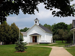
I make it a point to visit historical sites when I am on vacation but somehow I never take the time to see the historical sites that are within a Sunday’s drive from home.  So, when family arrived from California, I took a look at the map and suggested a trip to Okemos, Michigan to visit the Meridian Historical Village in picturesque Central Park.   There is not an entrance fee for this area but, if you feel inclined, donations are always appreciated.  

LOCATION5151 Marsh Road, Okemos, Michigan (USA)

Parking Your Car:  When you drive down Marsh Road (Village is on the west side of Marsh Road), look for the driveway to the Nokomis Learning Center (same address as the Historical Village).  This driveway will take you back to the public parking lot.   They ask that you not park in the lot next to the Village Chapel because it is intended for Meridian Township Fire and Public Safety personnel only. 

Planning Your VisitCentral Park is open daily.  However, the historic buildings are only open on Saturdays from 10 a.m. to 2 p.m. (May through October).  Most of the buildings are handicap accessible.  The Village is operated by the Friends of Historic Meridian and the buildings are manned on a volunteer basis.  As a result, the Saturday we were here, they were short-staffed so not all of the buildings were open during our visit. 
The seven buildings that make up this historic park were re-located here from around the general vicinity and restored to their 19th century appearance. 

Tollgate House (circa 1848)
Tollgate House
I never knew about wooden plank roads until I came here.  According to the Historical Village’s website “The Number 2 tollgate on the Lansing to Howell Plank Road was located on the south side of the current Grand River Avenue at Park Lake Road.  At one time, there were many gates and houses but this modest building is the only tollgate house that remains in Michigan today.”

General Store (built in 1877)
General Store - Exterior
General Store - Exhibit
General Store - Gift Shop Ideas
Originally located at the corner of Hamilton and Marsh Road, this two-story brick building was moved to the Village in 1988.  This is one of the three buildings that were open during our visit.  Inside the building is a small “general store exhibit” and gift shop. 

Barnes House (built in 1849)
Originally located on Okemos Road just south of Hamilton Road, this frame house was moved to the Village in 1997.  Over the years, the Barnes House has had many uses including a post office and millinery shop.  This is one of the buildings that we did not get the inside tour.

Grettenberger Farmhouse (built in the 1860’s)
This Greek-Revival style house was originally located on Marsh Road between Hamilton Road and Grand River Avenue.  It was the first building to be moved to the Village in 1973.  Unfortunately, this building was also closed during our visit.

Unruh Barn (built in the 1870’s)
This barn was originally located on the east side of Marsh Road just south of Tibert Road.  It was donated to the Village in 1991.  We were unable to see the exhibits inside the barn. 

Perkins-Copland Log Cabin (built early 1870’s)
The log cabin was moved to the Village in 2005.  This was another building we were unable to visit.

Randall Schoolhouse (built in 1883)
Randall Schoolhouse - Exterior and Interior
This one-room school was originally located on the northeast corner of Allen and Fowlerville Roads in Livingston County.  It was in use as a school until around 1975.   The Historical Village moved the school to its new location in 1987.  The desk, books and other items furnished inside the restored schoolhouse have been donated to the Village.  

There is a gazebo and a wooden observation deck (a Boy Scout project) near the small pond.  This is a quiet spot to enjoy nature.  

For more information on the Meridian Historical Village, please click on the following link:

If you come here on a Saturday (like we did), take a stroll through the Farmers Market located next to the Historical Village.   If you are in a shopping mood, the Meridian Mall is across the street.  If you are hungry, there are plenty of dining options from fast food to sit-down restaurants within a several blocks of the Village.