Yellowstone National Park was the world’s first National Park. It
is located mostly in the State of Wyoming (USA). There are very few
places in the world that are as diverse as the Yellowstone area. The
names of the places in Yellowstone remind me of alphabet soup. It has
everything from A to Z. While it took me some time to find and photograph each letter, I have finally completed my version of "Yellowstone: A to Z".
“A” is for Artist Paint Pot. In 1884, it was named
by geologist Walter Weed because the bright colorful mud reminded him
of the artist’s palette.
View of Artist Paint Pot
“B” is for Biscuit Basin. In the 1880’s, this basin got its
name from the knobby biscuit-like geyserite formations found in the
area. Most of the biscuits were destroyed during the 1959 earthquake
BIscuit Basin
“C” is for Cave Falls.
Located in the southwestern quadrant of the Park, the falls are 20
feet high and 250 feet wide. In the early 1920’s these falls got
their name because of their proximity to a small “cave”. Due to a rock slide, the
cave is no longer accessible.
View from cave (1989)
Cave Falls (2011)
“D” is for Daisy Geyser.
On the average, Daisy erupts to heights of 60-75 feet with an average
eruption lasting 3-5 minutes. Its predicted eruption times range
between 2-3 hours.
Daisy Geyser
“E” is for Electric Peak.
Located west of Mammoth, this 10,992’ high peak is part of the
Gallatin Mountain Range..
Electric Peak
“F” is for Fountain Paint
Pot. Apparently, the mud springs here reminded early visitors of a
vat of bubbling paint – a “paint pot”. In 1927, the name
“Fountain Paint Pot” was officially accepted.
Fountain Paint Pot
“G” is for Grand Canyon of
the Yellowstone River. The canyon is 24 miles in length, 800-1,200 feet deep and up to
4,000 feet wide. I think Harry J. Norton (in 1872) best described
the canyon by saying, “The subject is beyond the conception of the
most vivid imagination. Language is to inadequate to express the
unapproachable picture presented – the eye can only photograph the
gorgeous scene.”
Grand Canyon of the Yellowstone River
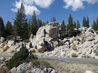
“H” is for “The
Hoodoos”. Not considered hoodoos in the traditional sense, they are
actually large travertine limestone boulders that fell in a landslide
from nearby Terrace Mountain. This area is full of these
large boulders. Just off the main road (near Rustic Falls) is a
short “U-shaped” paved road. This is a preserved portion of the
1899 stagecoach road passing through what is known as the Silver
Gate. Here, these large boulders line both sides of the old road.
It’s a quick and fun detour.
Hoodoos
The Hoodoos at Silver Gate
“I” is for Indian Pond.
Located about three miles east of Fishing Bridge, this was also known
as Squaw Lake. In 1981, Indian Pond became its official name.
Indian Pond
“J” is for Jupiter
Terrace. In 1871, members of the first Hayden expedition named this
terrace after the Roman god Jupiter. Like many thermal features,
Jupiter Terrace displays cycles of activity. For instance,
during our late 1980’s visit, the terrace was colorful with some
water flowing over its ledges. It has been dry since 1992.
Jupiter Terrace (2010)
Jupiter Terrace (1987)
“K” is for Kepler Cascades. The cascades drop approximately 150
feet over multiple drops with the longest drop being 50 feet. The
falls were named after 12-year old Kepler Hoyt who accompanied his
father and a group of men in 1881 in search of a practical route into
Yellowstone from the south.
Kepler Cascades
“L”
is for Lamar Valley. Located in the northeast corner of the park,
Lamar Valley is the “go to” spot for wildlife watchers. The
valley has been referred to as the Serengeti of America.
Lamar Valley
“M” is for Mystic Falls.
The Little Firehole River drops 70 feet to create the falls. The
trail to Mystic Falls is located at the back of the Biscuit Basin
near Avoca Spring. It is a 1.2 mile hike to the falls. From the
falls, you have two options. You can continue the loop trail for a total hike of three miles which includes climbing the
steep hillside for another 350 feet elevation change or you can return the way you came for a total hike of 2.4 miles. We have hiked both
options. Near the end of the loop trail is a somewhat lofty view of
the nearby geyser basins. We saw Old Faithful erupt from that point.
Mystic Falls
“N” is for Natural Bridge.
With a span of 29 feet, this natural bridge of rhyolite rock was
formed by frost and erosion. Located near the Lake area, the 1.2
mile (one way) hike follows an old road through a forest to the bridge. It was
lightly raining when we started our hike. I’m guessing that is what allowed us to have the trail and bridge view to ourselves.
Natural Bridge
“O” is for Old Faithful
Geyser. Old Faithful is the iconic geyser of Yellowstone National
Park. Considered one of the “must see” things in Yellowstone, it
was named in 1870 for its regular eruptions, However, it does not
erupt every 60 minutes. Over the years, vandalism and trash have
clogged the geyser’s tube disrupting the eruption pattern. Still
it is regular enough and accessible enough for visitors to gather and
wait and watch as the famous geyser erupts 130 feet (average eruption
height) into the air.
Old Faithful Geyser
“P” is for Petrified Tree.
Located 1.5 miles east of Tower Junction, this now fenced-in
specimen was one of two such petrified trees here. Unfortunately,
the other tree was the victim of souvenir seekers who destroyed it
piece by piece. Today, the fence and the law (which prohibits the
removal of such items from the Park) now protect the remains of this petrified tree.
Petrified Tree
“Q” is for Queen’s
Laundry. In 1880, a road (Old Fountain Trail) was being built.
Workers discovered an area in the nearby hot springs that was cool
enough for bathing and doing laundry. In 1881, the construction of a
two-room bath house began but it was never completed. The ruins of
that building still exist. On July 25, 2001, it was listed on the National Register of Historic Places.
Queen's Laundry
“R” is for Roaring
Mountain. In 1885, this landmark was aptly named Roaring Mountain.
Located on the main park road about five miles north of Norris Geyser
Basin, this mountain once “roared” loud and proud. Today, it
appears to be inactive.
Roaring Mountain
“S” is for Soda Butte.
This extinct hot spring cone is located in Lamar Valley and is easily
seen from the main park road.
Soda Butte
“T” is for Tuff Cliff.
This rock bluff was named in 1920 because it is made of compacted
volcanic ash known as tuff.
Tuff Cliff
“U” is for Union Falls.
Undine Falls might have been the more accessible choice to feature
here, However, I wanted to share Union Falls with you. Located in
the southwest quadrant of the Park, it is the second highest
waterfall (250 feet) in Yellowstone (the Lower Falls are 308 feet).
According to my 1989 trip notes, it was a 16 mile (round trip) day
hike requiring us to ford a couple of streams. We hit the trail
early … and so did about 100 boy scouts. It was a long day but the
falls were worth seeing. Back then, our cameras weren’t able to
capture the entire waterfall in one image. We had to take two
pictures to showcase the entire waterfall.
Union Falls
“V” is for Virginia
Cascade. This 60-foot long sloping cascade is located about two
miles east of Norris. Since this was America's first National Park, it was suggested that some of the features in the park be named after
different states of the Union. In 1886, the name “Virginia
Cascade” was made official. Today, the full view of the cascades
can not be seen from the road.
Virginia Cascades
“W” is for White Dome
Geyser. Located on Firehole Lake Drive (near Great Fountain Geyser),
this 12-foot geyserite cone can erupt as high as 30 feet with a
duration of about two minutes. The interval between eruptions range
from 15 minutes to three hours. When we arrived on the scene, White
Dome was nearing the end of its eruption cycle. We haven’t seen it
erupt before or after that visit.
White Dome Geyser
“X” is for … okay I’m
gonna take a little liberty here - Xanterra Parks &
Resorts. They are the authorized concessionaire of the National Park
Service and
have a long-time history with Yellowstone National Park
operating the lodging facilities, restaurants, campgrounds, and
providing activities and tours.
Xanterra Sign
Another thought is a cheater “X” - eXcelsior Geyser Crater.
During the 1880’s, this geyser was famous for its awesome eruptions
(up to 300 feet high). Located in the Midway Geyser Basin, this
large crater had thick clouds of steam constantly swirling around
it during our visit.
eXcelsior Geyser Crater
One last thought for the letter "X" …
Yellowstone got its name from the yellow-colored rocks found in the
Grand Canyon of the Yellowstone River. So what if we recognize the
yellow colors found in the rocks and hot springs that make up
Yellowstone National Park? I like using the Greek word for yellow –
Xanthos.
Xanthos-Colored Run-Off near Imperial Geyser
“Y” is for Yellowstone
Lake At 7,732 feet above sea level,
it is the largest lake in North America above 7,000 feet. It is 20 miles long and 14 miles wide with 110 miles of
shoreline making it one of the world’s largest natural fresh water
lakes. Its average depth is 140 feet but plunges to a depth of at
least 320 feet in the West Thumb area. Warning – the lake water
is cold all year.
Yellowstone Lake at West Thumb Geyser Basin
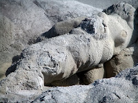
“Z” is for Zygomatic Arch.
This small arch is located in the Biscuit Basin (near Avoca Spring
at the back of the Basin).
Zygomatic Arch
For short but informative
videos about Yellowstone National Park, I recommend checking out the National Park Service's video series titled "Inside Yellowstone" by clicking on the following link:


