Thursday, March 29, 2018

Fiborn Quary - I Really Dig This Place

Let me begin by saying the Michigan Karst Conservancy owns the Fiborn Quarry property (an abandoned limestone quarry/ghost town in Mackinac County) and it is marked “No Trespassing”. Just for my own piece of mind, I call the Conservancy and get permission to go see it. For safety reasons, there are certain areas (like any caves) that we are not allowed to enter. We were also told that we might encounter some logging trucks on the narrow road. They can’t back up - but we can. So, we would have to put our vehicle in reverse and drive backwards until we could find a place wide enough for the truck to pass.

Our first attempt to see Fiborn Quarry was over the Fourth of July weekend (2017). Fiborn Quarry Road is a narrow gravel road with standing water filling the ditches on both sides of the road. After about a half mile, we begin to see the road is becoming dotted with large pot holes filled with water. We manage to drive around a large number of them until we came to a flooded stretch crossing the entire road. Since we are unfamiliar with what might lie ahead, we decide the current road conditions may become impassable for our regular car to negotiate without the fear of getting stuck. The rainy summer has also brought out the insects – lots of them. Taking all things into consideration (including the possibility of encountering a logging truck), we determine this might be a better adventure for us to do during the fall months.

Fast forward three months later … We spend the night at the Birch Lodge Inn (a Michigan Historic Site near the town of Trout Lake in Michigan’s Upper Peninsula). After breakfast, we head to Fiborn Quarry. From the Lodge’s driveway on H-40, it is seven miles to Fiborn Quarry Road.

I am happy to see the gravel road is dry - far better road condition than it was during our early July visit. In about 8/10's of a mile, we see the brown Michigan Karst Conservancy sign. At this point, the road makes a sharp right curve.
Sign
We drive approximately one mile to a small parking lot on the left side of the road. There is supposed to be a pavilion with a kiosk about the history of Fiborn Quarry (1905-1936) and the beginning of the 1.5 mile trail to the ruins. We don’t see it. Later, I find out we should have driven a little farther down the road to reach that point. In the meantime, I have a little history about the quarry from some Internet research.

According to the Michigan Karst Conservancy website, The Michigan Karst Conservancy purchased this 480-acre property in 1987 and established the Fiborn Karst Preserve, managing it as a natural area open to the public under guidelines meant to prevent damage to natural features, vandalism and unsupervised, unsafe cave exploration. A small town grew up next to the quarry, which included an elementary school, a boarding house, a company store and housing for employees and their families. Fiborn Karst Preserve features two self-guided trails highlighting natural and historic features. The Sinkhole Trail is a short loop past many shallow sinkholes and a creek disappearing below ground. The 1.5-mile Barbara Ann Patrie Memorial Trail travels along the edge of the quarry, through second-growth forest and past sinks, and Fiborn Pond.”

At this little parking lot there is an old road with a gated entrance. There are some people here that just finished their walk. They tell us this road will take us to the mining ruins. We walk around the gate and begin our easy half mile walk down the leafless tree-lined road toward this historic site.   
Road to Ruins
To our left is the quarry floor. Its gray rocky landscape reminds me of a moonscape. On our right is a limestone wall bathed in golden light from the late afternoon sun. Soon we see Fiborn Pond to our left. That means we are near the ruins.
Quarry Floor
 Limestone Wall
Fiborn Pond
Here’s the bad news - we have about an hour of daylight. The good news is - we will have the "ghost town" all to ourselves. So, we can enjoy the silence while we walk around the abandoned ruins.

We see the first building at Fiborn Quarry. It was used to sort and load the ore into the railroad cars. 
  Ore Sorting & Loading Building
Inside the Ore Sorting & Loading Building

Next, we go over to the large building where they stored and repaired the locomotives. Like the sign says – these are historic buildings please treat them with respect. You know the saying “take only pictures, leave only footprints”. The sunlight and shadows make for some interesting photo opportunities.
Locomotive Shed/Repair Shop
Sign
Light & Shadows Inside Building
The last building we see is the Powerhouse.
 Dry Cracked Ground near Power House
Ruins of Power House
Power House Wall
Shadows on Wall
The sun is sinking lower in the western sky when we notice the nearly full moon is already riding high in the early evening sky. That's our cue to hike back to the car.   

If you are interested in other Michigan ghost tows, I invite you to view my blog posts by clicking on the following links:
Since opinions, preferences, and budgets vary, I recommend checking a trusted travel source for current reviews on food and lodging.

Family vacations created some of my favorite memories. Start planning your next memorable trip today.

Friday, March 23, 2018

Keen on Keweenaw County Ghost Towns

The discovery of copper in Keweenaw County caused the creation of communities willing to accept the challenges and dangerous conditions of copper mining. Copper changed the face of Keweenaw County and served as a catalyst to economic success until its collapse in the last century.

Copper mining has been done for centuries. The Native Americans mined the copper to make tools and jewelry. According to Wikipedia, “In most years from 1850 through 1881, Michigan produced more than three-quarters of the nation's copper, and in 1869 produced more than 95% of the country's copper.

Eventually, the mines became unproductive and it wasn’t cost efficient to continue. Mining operations cease, the population declines, and a town dies … and that, my friends, is how a ghost town is born.

Obviously, copper and the communities surrounding the mines play an important role in Keweenaw’s history. These remnants of the past are here for us today ,,, it’s time to find some of Keweenaw County’s ghost towns.

Tuesday, March 13, 2018

Fayette is My Favorite Michigan Ghost Town

I have to admit it’s been awhile since we’ve been to the Garden Peninsula where the ghost town of Fayette can be found on the shore of Snail Shell Harbor and Lake Michigan. Located 17 miles south of US-2, in Michigan’s Upper Peninsula, it was a little “off the beaten path” for us but well worth the time to go see it.
Map Courtesy of Michigan Historical Center
During our two previous visits, we had the historic town pretty much to ourselves. This gave us the opportunity to walk around the buildings in silence and let our imaginations take us back to another time ...

That time would be 1867-1891 … At that time, nearly 500 residents lived in the town of Fayette which existed to make pig iron (used in steel making). The massive blast furnace is noisy and the work is hard and dirty. During its 24 years, Fayette produced nearly 230,000 tons of iron. The local hardwood forests were used for fuel and the quarried limestone from the bluffs was used to purify the iron ore. When the market began to decline, the Jackson Iron Company ceased its Fayette operations in 1891. Eventually, the town and buildings were abandoned and another Michigan ghost town was born.
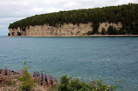
Limestone Bluffs at Snail Shell Harbor
The remains of the furnace complex and kilns  
Today, the town has been reconstructed and maintained as a museum. The historic town site includes 20 preserved buildings and structures. The hotel, company store, town hall, and some of the residences are open to the public.  The town site is open daily from mid-May to mid-October. There isn’t any admission fee to walk around the historic town site; however, a Michigan Recreation Passport is required to enter this State Park. 
Hotel
Company Store
Town Hall
Interior of Town Hall
Superintendent's House
Doctor's House
Views of Company Store, Town Hall, and Hotel from across the water

Of course, the well-preserved ghost town isn’t the only reason to come here. The park features close to five miles of hiking trails (used as cross-country ski trails in the winter).
Map Courtesy of Eye On Michigan
It’s an easy hike through the forest along the bluff trail to an overlook offering a panoramic view of the town and Snail Shell Harbor.
Forest Trail
Bluff view of Fayette and Snail Shell Harbor

How much time you spend here is up to you. We took our time … pack a picnic lunch and enjoy the views! However, a general recommendation is to allow at least two hours to tour the town site and enjoy the scenic beauty of this area.

On August 23, 1956, Fayette town site was designated a Michigan Historic Site. It became a State Park in 1959. It was listed on the National Register of Historic Places on February 16, 1970. A pretty prestigious proclamation for a properly preserved piece of property.

Thanks to the State of Michigan, Fayette is a ghost town that still lives to tell its story.  If you want to visit Fayette, the Park address is: 4785 II Rd, Garden, Michigan (USA) 49835
Telephone: (906) 644-2603

Looking for a place to spend the night? The State Park has a campground with 61 sites (some with electric service but no water or sewer hookups). Other lodging and food options can be found in Cooks (21.2 miles), Gladstone (46.4 miles), Escanaba (55.2 miles), and Manistique (33.6 miles).

Since opinions, preferences, and budgets vary, I recommend checking a trusted travel source for current reviews on food and lodging.
  
Family vacations created some of my favorite memories. To start planning your memorable trip to Fayette Historic Town Site/State Park, please click on the following link:

Interested in more ghost towns? I invite you to view some of my other blog posts by clicking on the following links:
Alcona Village - Alcona County Historic Sites
Old Victoria - An Old Mining Town Finds A New Life

Friday, March 2, 2018

Geology Rocks the Imagination

Digital manipulation has taught us you can't believe everything you see ... but what if it is literally etched in stone?   Rock formations are geologic wonders created by time and circumstance.  For me, rocks aren't just piles of stones - they challenge my imagination.  Some people look at clouds and see interesting formations.  I look at rocks the same way.  Look closely ... what do you see?
I see an owl.
One of my favorite rock formations is in Alaska.  During a discovery cruise between Homer and Seldovia, the Captain of our boat told us to watch a certain rock in the water.  As we approach the rock, it looks like an elephant with its trunk in the water.
As we sail by the rock, it appears the elephant is holding its trunk up out of the water.  How cool is that!
When scanning a rocky landscape, we frequently find animal shapes.  Some features are unmistakable while others require a bit more imagination.  Here are a few of my favorites:
 
Humpback Whale - Blue Ridge Parkwway
Duck on a Rock - Chiricahua National Monument, Arizona
Camel Head - Chiricahua National Monument, Arizona
Sheep Rock - Arches National Park, Utah
Gopher - Arches National Park, Utah
Billy Goat Head - Capitol Reef National Park, Utah
Head of a Triceratops Dinosaur - Capitol Reef National Park, Utah
Plucked Turkey
Dolphin Head - Capitol Reef National Park, Utah
Head of an Animal Lying on the Ground - Arches National Park, Utah
Elephant & Cheese - Canyonlands National Park, Utah
Parade of Elephants - Arches National Park, Utah
Some rock formations evoke a more sinister mood.
I see a rock monster with its mouth open wide ... waiting silently ... but for what ... or who?
This eerie formation resembles a half-buried skull.

How about taking a walk through a valley filled with goblins?
Goblin Valley State Park - Utah
It doesn't take much imagination to see the "Mittens" or the "OK" hand sign of Turret Arch.
Monument Valley - Arizona
Arches National Park - Utah
If we have the time, we look for faces in the rocks but imagining the rocks as people is an easier task.  For instance, the Three Gossips or the Kissing Couple are good examples of this.
Three Gossips - Arches National Park, Utah
Kissing Couple - Arizona
Are you wondering if this post can offer a royal "happily ever after"?  Look no further than Miners Castle and the Golden Throne.
 Miners Castle - Pictured Rocks NLS, Michigan
Golden Throne - Capitol Reef National Park, Utah
The next time your family is visiting a scenic area, challenge each other to look for the imaginative shapes in nature.  It's a fun way to see why geology rocks!